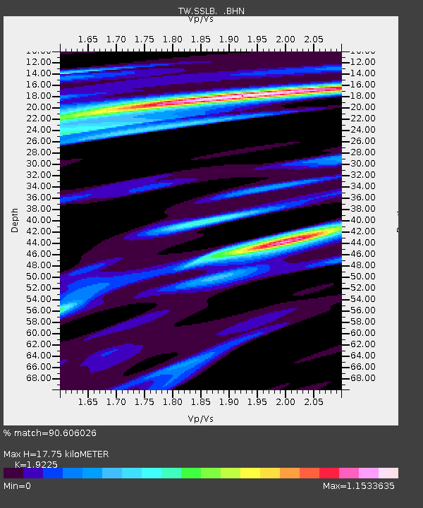
SSLB SUANG-LONG - Earthquake Result Viewer

Earthquake location: South Of Java, Indonesia
Earthquake latitude/longitude: -10.2/110.6
Earthquake time(UTC): 2009/09/07 (250) 16:12:22 GMT
Earthquake Depth: 23 km
Earthquake Magnitude: 6.1 MB, 5.9 MS, 6.2 MW, 6.1 MW
Earthquake Catalog/Contributor: WHDF/NEIC
Network: TW Broadband Array in Taiwan for Seismology
Station: SSLB SUANG-LONG
Lat/Lon: 23.79 N/120.95 E
Elevation: 450 m
Distance: 35.3 deg
Az: 16.528 deg
Baz: 197.801 deg
Ray Param: 0.07728827
Estimated Moho Depth: 17.75 km
Estimated Crust Vp/Vs: 1.92
Assumed Crust Vp: 6.461 km/s
Estimated Crust Vs: 3.361 km/s
Estimated Crust Poisson's Ratio: 0.31
Radial Match: 90.606026 %
Radial Bump: 400
Transverse Match: 82.23206 %
Transverse Bump: 400
SOD ConfigId: 2622
Insert Time: 2010-03-09 21:51:51.174 +0000
GWidth: 2.5
Max Bumps: 400
Tol: 0.001

Signal To Noise

ChannelStoNSTALTA
TW:SSLB: :BHN:20090907T16:18:44.669009Z8.5423382.5462477E-62.9807384E-7
TW:SSLB: :BHE:20090907T16:18:44.669009Z10.7934641.4171222E-61.3129448E-7
TW:SSLB: :BHZ:20090907T16:18:44.669009Z1.27125173.3480666E-72.6336772E-7
Arrivals
Ps2.7 SECOND
PpPs7.5 SECOND
PsPs/PpSs10 SECOND