You are here: Home > Network List > AV - Alaska Volcano Observatory Stations List
> Station SPCG Capps Glacier, Mount Spurr, Alaska > Earthquake Result Viewer
SPCG Capps Glacier, Mount Spurr, Alaska - Earthquake Result Viewer
| Earthquake location: |
Hokkaido, Japan Region |
| Earthquake latitude/longitude: |
45.9/142.1 |
| Earthquake time(UTC): |
2022/07/02 (183) 01:59:45 GMT |
| Earthquake Depth: |
322 km |
| Earthquake Magnitude: |
5.8 mww |
| Earthquake Catalog/Contributor: |
NEIC PDE/us |
|
| Network: |
AV Alaska Volcano Observatory |
| Station: |
SPCG Capps Glacier, Mount Spurr, Alaska |
| Lat/Lon: |
61.29 N/152.02 W |
| Elevation: |
1329 m |
|
| Distance: |
40.1 deg |
| Az: |
43.125 deg |
| Baz: |
278.5 deg |
| Ray Param: |
0.073226705 |
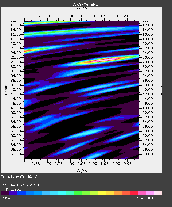
| Estimated Moho Depth: |
26.75 km |
| Estimated Crust Vp/Vs: |
1.96 |
| Assumed Crust Vp: |
6.566 km/s |
| Estimated Crust Vs: |
3.359 km/s |
| Estimated Crust Poisson's Ratio: |
0.32 |
|
| Radial Match: |
83.46273 % |
| Radial Bump: |
400 |
| Transverse Match: |
88.41315 % |
| Transverse Bump: |
400 |
| SOD ConfigId: |
28208852 |
| Insert Time: |
2022-07-16 02:09:29.696 +0000 |
| GWidth: |
2.5 |
| Max Bumps: |
400 |
| Tol: |
0.001 |
|

Signal To Noise
| Channel | StoN | STA | LTA |
| AV:SPCG: :BHZ:20220702T02:06:20.898985Z | 29.600534 | 1.330474E-6 | 4.4947633E-8 |
| AV:SPCG: :BHN:20220702T02:06:20.898985Z | 9.481396 | 5.0330885E-7 | 5.3083838E-8 |
| AV:SPCG: :BHE:20220702T02:06:20.898985Z | 7.415523 | 4.7078436E-7 | 6.348633E-8 |
| Arrivals |
| Ps | 4.1 SECOND |
| PpPs | 11 SECOND |
| PsPs/PpSs | 15 SECOND |


