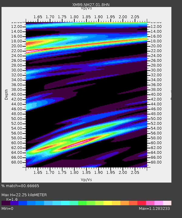
NM27 NewMexico27 - Earthquake Result Viewer

Earthquake location: Central Peru
Earthquake latitude/longitude: -11.3/-74.5
Earthquake time(UTC): 2001/02/21 (052) 15:20:21 GMT
Earthquake Depth: 33 km
Earthquake Magnitude: 5.5 MB, 5.2 MS, 5.8 MW, 5.8 MW
Earthquake Catalog/Contributor: WHDF/NEIC
Network: XM Rio Grande Seismic Transect
Station: NM27 NewMexico27
Lat/Lon: 34.39 N/106.52 W
Elevation: 1870 m
Distance: 54.6 deg
Az: 327.485 deg
Baz: 140.389 deg
Ray Param: 0.06526228
Estimated Moho Depth: 22.25 km
Estimated Crust Vp/Vs: 1.60
Assumed Crust Vp: 6.502 km/s
Estimated Crust Vs: 4.063 km/s
Estimated Crust Poisson's Ratio: 0.18
Radial Match: 80.66665 %
Radial Bump: 377
Transverse Match: 76.31508 %
Transverse Bump: 370
SOD ConfigId: 3753
Insert Time: 2010-02-26 17:31:56.971 +0000
GWidth: 2.5
Max Bumps: 400
Tol: 0.001

Signal To Noise

ChannelStoNSTALTA
XM:NM27:01:BHN:20010221T15:29:16.265Z1.75522551.2866764E-77.330547E-8
XM:NM27:01:BHE:20010221T15:29:16.265Z2.08847572.1065405E-71.0086498E-7
XM:NM27:01:BHZ:20010221T15:29:16.265Z2.22891042.3737803E-71.0649958E-7
Arrivals
Ps2.2 SECOND
PpPs8.4 SECOND
PsPs/PpSs11 SECOND