You are here: Home > Network List > C0 - Colorado Geological Survey Seismic Network Stations List
> Station N23A Red Feather Lakes, CO > Earthquake Result Viewer
N23A Red Feather Lakes, CO - Earthquake Result Viewer
| Earthquake location: |
Hokkaido, Japan Region |
| Earthquake latitude/longitude: |
45.9/142.1 |
| Earthquake time(UTC): |
2022/07/02 (183) 01:59:45 GMT |
| Earthquake Depth: |
322 km |
| Earthquake Magnitude: |
5.8 mww |
| Earthquake Catalog/Contributor: |
NEIC PDE/us |
|
| Network: |
C0 Colorado Geological Survey Seismic Network |
| Station: |
N23A Red Feather Lakes, CO |
| Lat/Lon: |
40.89 N/105.94 W |
| Elevation: |
2452 m |
|
| Distance: |
74.4 deg |
| Az: |
46.896 deg |
| Baz: |
317.718 deg |
| Ray Param: |
0.051450253 |
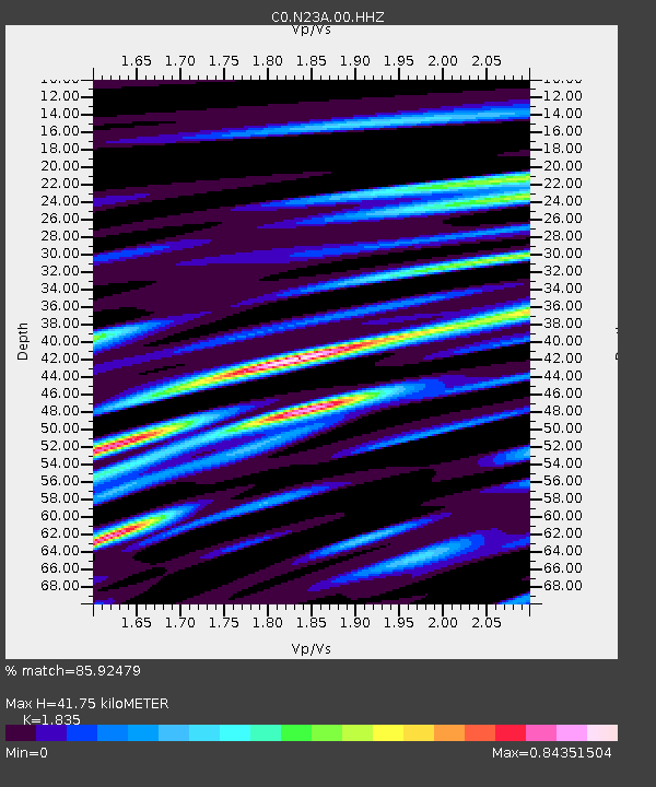
| Estimated Moho Depth: |
41.75 km |
| Estimated Crust Vp/Vs: |
1.84 |
| Assumed Crust Vp: |
6.306 km/s |
| Estimated Crust Vs: |
3.437 km/s |
| Estimated Crust Poisson's Ratio: |
0.29 |
|
| Radial Match: |
85.92479 % |
| Radial Bump: |
400 |
| Transverse Match: |
83.04525 % |
| Transverse Bump: |
400 |
| SOD ConfigId: |
28208852 |
| Insert Time: |
2022-07-16 02:11:23.612 +0000 |
| GWidth: |
2.5 |
| Max Bumps: |
400 |
| Tol: |
0.001 |
|

Signal To Noise
| Channel | StoN | STA | LTA |
| C0:N23A:00:HHZ:20220702T02:10:18.138975Z | 19.268332 | 1.10188E-6 | 5.718606E-8 |
| C0:N23A:00:HHN:20220702T02:10:18.138975Z | 6.3772073 | 3.4120467E-7 | 5.3503776E-8 |
| C0:N23A:00:HHE:20220702T02:10:18.138975Z | 8.941482 | 3.8227216E-7 | 4.2752664E-8 |
| Arrivals |
| Ps | 5.7 SECOND |
| PpPs | 18 SECOND |
| PsPs/PpSs | 24 SECOND |


