You are here: Home > Network List > CC - Cascade Chain Volcano Monitoring Stations List
> Station UNFR Upper North Fork Repeater > Earthquake Result Viewer
UNFR Upper North Fork Repeater - Earthquake Result Viewer
| Earthquake location: |
Hokkaido, Japan Region |
| Earthquake latitude/longitude: |
45.9/142.1 |
| Earthquake time(UTC): |
2022/07/02 (183) 01:59:45 GMT |
| Earthquake Depth: |
322 km |
| Earthquake Magnitude: |
5.8 mww |
| Earthquake Catalog/Contributor: |
NEIC PDE/us |
|
| Network: |
CC Cascade Chain Volcano Monitoring |
| Station: |
UNFR Upper North Fork Repeater |
| Lat/Lon: |
46.27 N/122.29 W |
| Elevation: |
884 m |
|
| Distance: |
62.1 deg |
| Az: |
51.382 deg |
| Baz: |
308.108 deg |
| Ray Param: |
0.059394315 |
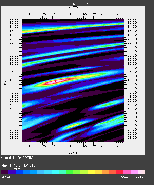
| Estimated Moho Depth: |
40.5 km |
| Estimated Crust Vp/Vs: |
1.76 |
| Assumed Crust Vp: |
6.566 km/s |
| Estimated Crust Vs: |
3.725 km/s |
| Estimated Crust Poisson's Ratio: |
0.26 |
|
| Radial Match: |
84.19753 % |
| Radial Bump: |
400 |
| Transverse Match: |
70.036385 % |
| Transverse Bump: |
400 |
| SOD ConfigId: |
28208852 |
| Insert Time: |
2022-07-16 02:13:19.263 +0000 |
| GWidth: |
2.5 |
| Max Bumps: |
400 |
| Tol: |
0.001 |
|

Signal To Noise
| Channel | StoN | STA | LTA |
| CC:UNFR: :BHZ:20220702T02:09:02.419981Z | 19.695393 | 1.4119062E-6 | 7.168713E-8 |
| CC:UNFR: :BHN:20220702T02:09:02.419981Z | 6.989474 | 5.360321E-7 | 7.6691336E-8 |
| CC:UNFR: :BHE:20220702T02:09:02.419981Z | 11.930932 | 6.062773E-7 | 5.0815583E-8 |
| Arrivals |
| Ps | 4.9 SECOND |
| PpPs | 16 SECOND |
| PsPs/PpSs | 21 SECOND |


