You are here: Home > Network List > XM99 - Rio Grande Seismic Transect Stations List
> Station NM27 NewMexico27 > Earthquake Result Viewer
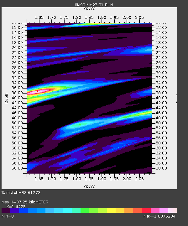
NM27 NewMexico27 - Earthquake Result Viewer
| Earthquake location: |
Northern Chile |
| Earthquake latitude/longitude: |
-18.9/-69.2 |
| Earthquake time(UTC): |
1999/11/30 (334) 04:01:53 GMT |
| Earthquake Depth: |
128 km |
| Earthquake Magnitude: |
6.2 MB, 6.6 MW, 6.5 MW |
| Earthquake Catalog/Contributor: |
WHDF/NEIC |
|
| Network: |
XM Rio Grande Seismic Transect |
| Station: |
NM27 NewMexico27 |
| Lat/Lon: |
34.39 N/106.52 W |
| Elevation: |
1870 m |
|
| Distance: |
63.8 deg |
| Az: |
326.0 deg |
| Baz: |
140.198 deg |
| Ray Param: |
0.058970336 |
| Estimated Moho Depth: |
37.25 km |
| Estimated Crust Vp/Vs: |
1.64 |
| Assumed Crust Vp: |
6.502 km/s |
| Estimated Crust Vs: |
3.958 km/s |
| Estimated Crust Poisson's Ratio: |
0.21 |
|
| Radial Match: |
88.61273 % |
| Radial Bump: |
400 |
| Transverse Match: |
66.91316 % |
| Transverse Bump: |
400 |
| SOD ConfigId: |
27569 |
| Insert Time: |
2010-02-26 17:31:58.122 +0000 |
| GWidth: |
2.5 |
| Max Bumps: |
400 |
| Tol: |
0.001 |
|

Signal To Noise
| Channel | StoN | STA | LTA |
| XM:NM27:01:BHN:19991130T04:11:41.032012Z | 1.4889424 | 5.8234815E-7 | 3.911153E-7 |
| XM:NM27:01:BHE:19991130T04:11:41.032012Z | 1.754152 | 5.005557E-7 | 2.853548E-7 |
| XM:NM27:01:BHZ:19991130T04:11:41.032012Z | 3.0276217 | 1.5902555E-6 | 5.2524905E-7 |
| Arrivals |
| Ps | 3.9 SECOND |
| PpPs | 14 SECOND |
| PsPs/PpSs | 18 SECOND |


