You are here: Home > Network List > US - United States National Seismic Network Stations List
> Station MSO Missoula, Montana, USA > Earthquake Result Viewer
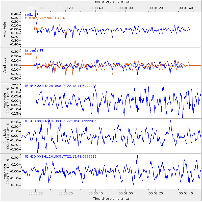
MSO Missoula, Montana, USA - Earthquake Result Viewer
*The percent match for this event was below the threshold and hence no stack was calculated.
| Earthquake location: |
Volcano Islands, Japan Region |
| Earthquake latitude/longitude: |
23.5/143.3 |
| Earthquake time(UTC): |
2018/08/17 (229) 22:06:57 GMT |
| Earthquake Depth: |
18 km |
| Earthquake Magnitude: |
5.5 Mww |
| Earthquake Catalog/Contributor: |
NEIC PDE/us |
|
| Network: |
US United States National Seismic Network |
| Station: |
MSO Missoula, Montana, USA |
| Lat/Lon: |
46.83 N/113.94 W |
| Elevation: |
1264 m |
|
| Distance: |
81.4 deg |
| Az: |
42.639 deg |
| Baz: |
295.066 deg |
| Ray Param: |
$rayparam |
*The percent match for this event was below the threshold and hence was not used in the summary stack. |
|
| Radial Match: |
73.33605 % |
| Radial Bump: |
400 |
| Transverse Match: |
57.81499 % |
| Transverse Bump: |
400 |
| SOD ConfigId: |
2825771 |
| Insert Time: |
2018-08-31 22:15:01.838 +0000 |
| GWidth: |
2.5 |
| Max Bumps: |
400 |
| Tol: |
0.001 |
|
Signal To Noise
| Channel | StoN | STA | LTA |
| US:MSO:00:BHZ:20180817T22:18:41.699998Z | 2.4202232 | 1.7469497E-7 | 7.218135E-8 |
| US:MSO:00:BH1:20180817T22:18:41.699998Z | 1.1096286 | 5.485533E-8 | 4.9435762E-8 |
| US:MSO:00:BH2:20180817T22:18:41.699998Z | 1.1453586 | 5.534644E-8 | 4.832237E-8 |
| Arrivals |
| Ps | |
| PpPs | |
| PsPs/PpSs | |


