You are here: Home > Network List > TW - Broadband Array in Taiwan for Seismology Stations List
> Station SSLB SUANG-LONG > Earthquake Result Viewer
SSLB SUANG-LONG - Earthquake Result Viewer
| Earthquake location: |
Fiji Islands Region |
| Earthquake latitude/longitude: |
-21.2/-179.1 |
| Earthquake time(UTC): |
2000/12/18 (353) 01:19:21 GMT |
| Earthquake Depth: |
628 km |
| Earthquake Magnitude: |
6.4 MB, 6.6 MW, 6.5 MW |
| Earthquake Catalog/Contributor: |
WHDF/NEIC |
|
| Network: |
TW Broadband Array in Taiwan for Seismology |
| Station: |
SSLB SUANG-LONG |
| Lat/Lon: |
23.79 N/120.95 E |
| Elevation: |
450 m |
|
| Distance: |
73.5 deg |
| Az: |
304.225 deg |
| Baz: |
122.606 deg |
| Ray Param: |
0.05084954 |
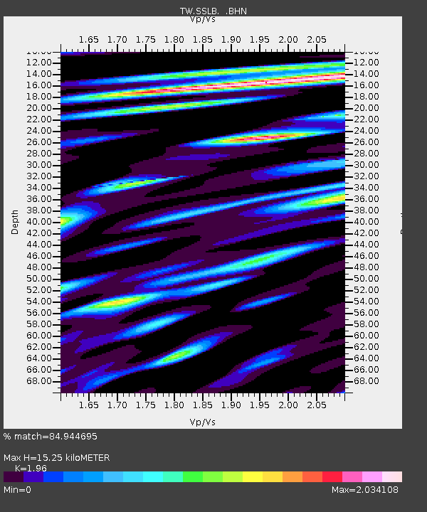
| Estimated Moho Depth: |
15.25 km |
| Estimated Crust Vp/Vs: |
1.96 |
| Assumed Crust Vp: |
6.461 km/s |
| Estimated Crust Vs: |
3.297 km/s |
| Estimated Crust Poisson's Ratio: |
0.32 |
|
| Radial Match: |
84.944695 % |
| Radial Bump: |
400 |
| Transverse Match: |
79.8748 % |
| Transverse Bump: |
400 |
| SOD ConfigId: |
3744 |
| Insert Time: |
2010-03-09 21:53:46.937 +0000 |
| GWidth: |
2.5 |
| Max Bumps: |
400 |
| Tol: |
0.001 |
|

Signal To Noise
| Channel | StoN | STA | LTA |
| TW:SSLB: :BHN:20001218T01:29:20.980994Z | 31.62709 | 5.8222518E-6 | 1.8409065E-7 |
| TW:SSLB: :BHE:20001218T01:29:20.980994Z | 22.925583 | 5.8854507E-6 | 2.567198E-7 |
| TW:SSLB: :BHZ:20001218T01:29:20.980994Z | 33.74088 | 8.990385E-6 | 2.6645378E-7 |
| Arrivals |
| Ps | 2.3 SECOND |
| PpPs | 6.8 SECOND |
| PsPs/PpSs | 9.1 SECOND |


