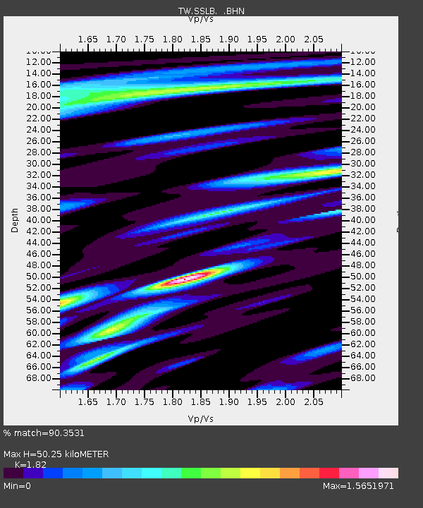
SSLB SUANG-LONG - Earthquake Result Viewer

Earthquake location: South Of Australia
Earthquake latitude/longitude: -42.8/124.7
Earthquake time(UTC): 2001/12/12 (346) 14:02:35 GMT
Earthquake Depth: 10 km
Earthquake Magnitude: 6.5 MB, 6.7 MS, 7.1 MW, 7.0 MW
Earthquake Catalog/Contributor: WHDF/NEIC
Network: TW Broadband Array in Taiwan for Seismology
Station: SSLB SUANG-LONG
Lat/Lon: 23.79 N/120.95 E
Elevation: 450 m
Distance: 66.4 deg
Az: 356.266 deg
Baz: 177.001 deg
Ray Param: 0.05766971
Estimated Moho Depth: 50.25 km
Estimated Crust Vp/Vs: 1.82
Assumed Crust Vp: 6.461 km/s
Estimated Crust Vs: 3.55 km/s
Estimated Crust Poisson's Ratio: 0.28
Radial Match: 90.3531 %
Radial Bump: 400
Transverse Match: 91.80605 %
Transverse Bump: 400
SOD ConfigId: 20082
Insert Time: 2010-03-09 21:53:55.857 +0000
GWidth: 2.5
Max Bumps: 400
Tol: 0.001

Signal To Noise

ChannelStoNSTALTA
TW:SSLB: :BHN:20011212T14:12:52.678Z2.35132224.6546944E-71.9796073E-7
TW:SSLB: :BHE:20011212T14:12:52.678Z0.664701462.1194454E-73.1885673E-7
TW:SSLB: :BHZ:20011212T14:12:52.678Z7.5793171.199398E-61.5824618E-7
Arrivals
Ps6.6 SECOND
PpPs21 SECOND
PsPs/PpSs28 SECOND