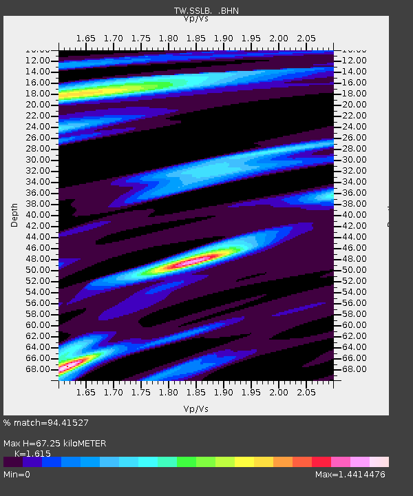
SSLB SUANG-LONG - Earthquake Result Viewer

Earthquake location: Southern Sumatra, Indonesia
Earthquake latitude/longitude: -4.7/102.6
Earthquake time(UTC): 2001/02/13 (044) 19:28:30 GMT
Earthquake Depth: 36 km
Earthquake Magnitude: 6.2 MB, 7.2 MS, 7.4 MW, 7.0 ME
Earthquake Catalog/Contributor: WHDF/NEIC
Network: TW Broadband Array in Taiwan for Seismology
Station: SSLB SUANG-LONG
Lat/Lon: 23.79 N/120.95 E
Elevation: 450 m
Distance: 33.5 deg
Az: 31.578 deg
Baz: 214.734 deg
Ray Param: 0.07811741
Estimated Moho Depth: 67.25 km
Estimated Crust Vp/Vs: 1.62
Assumed Crust Vp: 6.461 km/s
Estimated Crust Vs: 4.001 km/s
Estimated Crust Poisson's Ratio: 0.19
Radial Match: 94.41527 %
Radial Bump: 318
Transverse Match: 89.13906 %
Transverse Bump: 400
SOD ConfigId: 3744
Insert Time: 2010-03-09 21:54:01.943 +0000
GWidth: 2.5
Max Bumps: 400
Tol: 0.001

Signal To Noise

ChannelStoNSTALTA
TW:SSLB: :BHN:20010213T19:34:35.967001Z1.37018337.121806E-75.197703E-7
TW:SSLB: :BHE:20010213T19:34:35.967001Z1.06747214.0160538E-73.7622095E-7
TW:SSLB: :BHZ:20010213T19:34:35.967001Z0.43039523.1094228E-77.224576E-7
Arrivals
Ps7.0 SECOND
PpPs25 SECOND
PsPs/PpSs32 SECOND