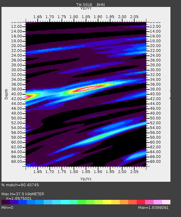
SSLB SUANG-LONG - Earthquake Result Viewer

Earthquake location: Kuril Islands
Earthquake latitude/longitude: 44.3/148.4
Earthquake time(UTC): 2001/05/25 (145) 00:40:50 GMT
Earthquake Depth: 33 km
Earthquake Magnitude: 6.1 MB, 6.7 MS, 6.7 MW, 6.6 MW
Earthquake Catalog/Contributor: WHDF/NEIC
Network: TW Broadband Array in Taiwan for Seismology
Station: SSLB SUANG-LONG
Lat/Lon: 23.79 N/120.95 E
Elevation: 450 m
Distance: 30.3 deg
Az: 236.691 deg
Baz: 40.952 deg
Ray Param: 0.07932748
Estimated Moho Depth: 37.5 km
Estimated Crust Vp/Vs: 1.86
Assumed Crust Vp: 6.461 km/s
Estimated Crust Vs: 3.479 km/s
Estimated Crust Poisson's Ratio: 0.30
Radial Match: 90.40745 %
Radial Bump: 400
Transverse Match: 70.8038 %
Transverse Bump: 400
SOD ConfigId: 4714
Insert Time: 2010-03-09 21:54:05.656 +0000
GWidth: 2.5
Max Bumps: 400
Tol: 0.001

Signal To Noise

ChannelStoNSTALTA
TW:SSLB: :BHN:20010525T00:46:28.902002Z10.5628038.663842E-78.202219E-8
TW:SSLB: :BHE:20010525T00:46:28.902002Z5.06595758.153346E-71.6094383E-7
TW:SSLB: :BHZ:20010525T00:46:28.902002Z25.2306881.57659E-66.2487E-8
Arrivals
Ps5.4 SECOND
PpPs15 SECOND
PsPs/PpSs21 SECOND