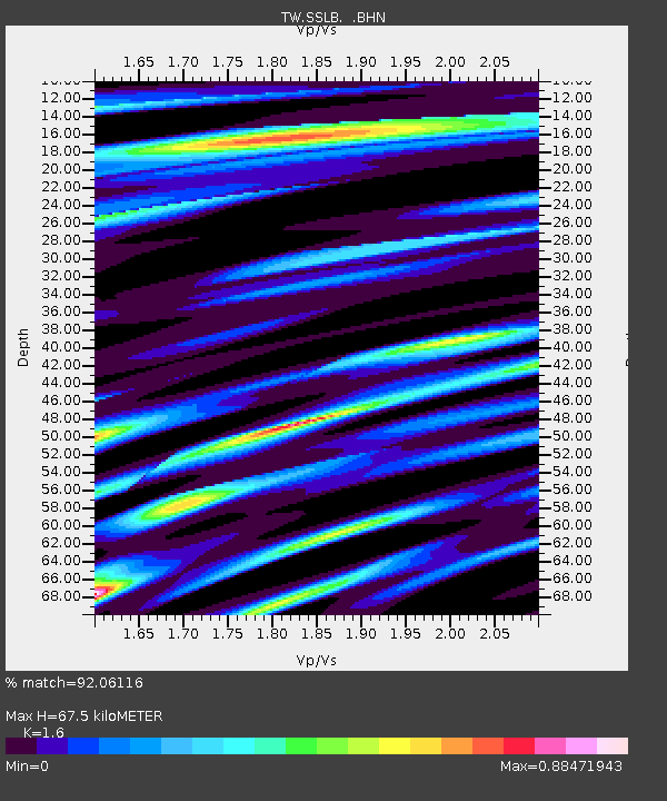
SSLB SUANG-LONG - Earthquake Result Viewer

Earthquake location: Southern Sumatra, Indonesia
Earthquake latitude/longitude: -3.1/100.5
Earthquake time(UTC): 2009/04/15 (105) 20:01:34 GMT
Earthquake Depth: 20 km
Earthquake Magnitude: 6.1 MB, 6.4 MS, 6.4 MW, 6.2 MW
Earthquake Catalog/Contributor: WHDF/NEIC
Network: TW Broadband Array in Taiwan for Seismology
Station: SSLB SUANG-LONG
Lat/Lon: 23.79 N/120.95 E
Elevation: 450 m
Distance: 33.4 deg
Az: 35.657 deg
Baz: 219.452 deg
Ray Param: 0.078220725
Estimated Moho Depth: 67.5 km
Estimated Crust Vp/Vs: 1.60
Assumed Crust Vp: 6.461 km/s
Estimated Crust Vs: 4.038 km/s
Estimated Crust Poisson's Ratio: 0.18
Radial Match: 92.06116 %
Radial Bump: 379
Transverse Match: 71.8589 %
Transverse Bump: 400
SOD ConfigId: 2658
Insert Time: 2010-03-09 21:54:36.068 +0000
GWidth: 2.5
Max Bumps: 400
Tol: 0.001

Signal To Noise

ChannelStoNSTALTA
TW:SSLB: :BHN:20090415T20:07:40.520015Z46.0398754.67298E-61.01498536E-7
TW:SSLB: :BHE:20090415T20:07:40.520015Z23.96311.6583904E-66.9205996E-8
TW:SSLB: :BHZ:20090415T20:07:40.520015Z16.1680771.6083968E-69.947979E-8
Arrivals
Ps6.8 SECOND
PpPs25 SECOND
PsPs/PpSs32 SECOND