You are here: Home > Network List > TW - Broadband Array in Taiwan for Seismology Stations List
> Station SSLB SUANG-LONG > Earthquake Result Viewer
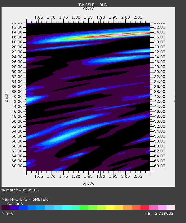
SSLB SUANG-LONG - Earthquake Result Viewer
| Earthquake location: |
Kermadec Islands Region |
| Earthquake latitude/longitude: |
-31.5/-178.8 |
| Earthquake time(UTC): |
2009/05/16 (136) 00:53:52 GMT |
| Earthquake Depth: |
55 km |
| Earthquake Magnitude: |
6.1 MB, 6.5 MW, 6.3 MW |
| Earthquake Catalog/Contributor: |
WHDF/NEIC |
|
| Network: |
TW Broadband Array in Taiwan for Seismology |
| Station: |
SSLB SUANG-LONG |
| Lat/Lon: |
23.79 N/120.95 E |
| Elevation: |
450 m |
|
| Distance: |
79.7 deg |
| Az: |
306.053 deg |
| Baz: |
131.085 deg |
| Ray Param: |
0.04870748 |
| Estimated Moho Depth: |
14.75 km |
| Estimated Crust Vp/Vs: |
1.99 |
| Assumed Crust Vp: |
6.461 km/s |
| Estimated Crust Vs: |
3.255 km/s |
| Estimated Crust Poisson's Ratio: |
0.33 |
|
| Radial Match: |
85.95037 % |
| Radial Bump: |
400 |
| Transverse Match: |
78.667465 % |
| Transverse Bump: |
400 |
| SOD ConfigId: |
2760 |
| Insert Time: |
2010-03-09 21:54:38.990 +0000 |
| GWidth: |
2.5 |
| Max Bumps: |
400 |
| Tol: |
0.001 |
|

Signal To Noise
| Channel | StoN | STA | LTA |
| TW:SSLB: :BHN:20090516T01:05:23.370005Z | 16.450142 | 1.4009172E-6 | 8.51614E-8 |
| TW:SSLB: :BHE:20090516T01:05:23.370005Z | 10.615766 | 4.610229E-7 | 4.3428134E-8 |
| TW:SSLB: :BHZ:20090516T01:05:23.370005Z | 11.848129 | 6.902262E-7 | 5.8256134E-8 |
| Arrivals |
| Ps | 2.3 SECOND |
| PpPs | 6.6 SECOND |
| PsPs/PpSs | 8.9 SECOND |


