You are here: Home > Network List > OH - Ohio Seismic Network Stations List
> Station KLOH Kiser Lake State Park Ohio > Earthquake Result Viewer
KLOH Kiser Lake State Park Ohio - Earthquake Result Viewer
| Earthquake location: |
Hokkaido, Japan Region |
| Earthquake latitude/longitude: |
45.9/142.1 |
| Earthquake time(UTC): |
2022/07/02 (183) 01:59:45 GMT |
| Earthquake Depth: |
322 km |
| Earthquake Magnitude: |
5.8 mww |
| Earthquake Catalog/Contributor: |
NEIC PDE/us |
|
| Network: |
OH Ohio Seismic Network |
| Station: |
KLOH Kiser Lake State Park Ohio |
| Lat/Lon: |
40.20 N/83.97 W |
| Elevation: |
350 m |
|
| Distance: |
84.9 deg |
| Az: |
33.645 deg |
| Baz: |
329.651 deg |
| Ray Param: |
0.044336867 |
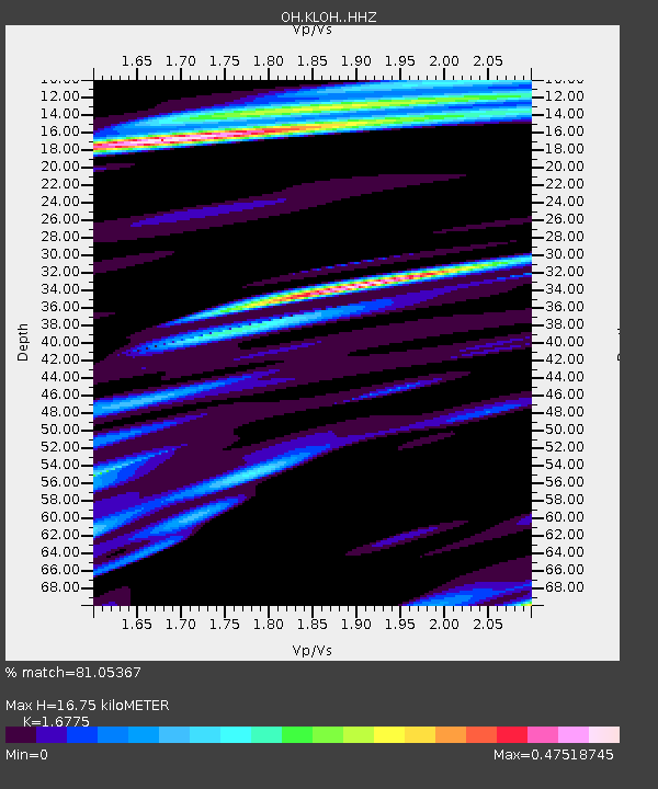
| Estimated Moho Depth: |
16.75 km |
| Estimated Crust Vp/Vs: |
1.68 |
| Assumed Crust Vp: |
6.498 km/s |
| Estimated Crust Vs: |
3.873 km/s |
| Estimated Crust Poisson's Ratio: |
0.22 |
|
| Radial Match: |
81.05367 % |
| Radial Bump: |
400 |
| Transverse Match: |
56.981712 % |
| Transverse Bump: |
400 |
| SOD ConfigId: |
28208852 |
| Insert Time: |
2022-07-16 02:32:09.123 +0000 |
| GWidth: |
2.5 |
| Max Bumps: |
400 |
| Tol: |
0.001 |
|

Signal To Noise
| Channel | StoN | STA | LTA |
| OH:KLOH: :HHZ:20220702T02:11:13.919981Z | 15.538954 | 1.5471752E-6 | 9.956753E-8 |
| OH:KLOH: :HHN:20220702T02:11:13.919981Z | 8.425306 | 5.29181E-7 | 6.2808525E-8 |
| OH:KLOH: :HHE:20220702T02:11:13.919981Z | 2.3403347 | 3.7637267E-7 | 1.6082004E-7 |
| Arrivals |
| Ps | 1.8 SECOND |
| PpPs | 6.7 SECOND |
| PsPs/PpSs | 8.5 SECOND |


