You are here: Home > Network List > GS - US Geological Survey Networks Stations List
> Station DEC06 Boomer > Earthquake Result Viewer
DEC06 Boomer - Earthquake Result Viewer
| Earthquake location: |
Costa Rica |
| Earthquake latitude/longitude: |
8.8/-83.2 |
| Earthquake time(UTC): |
2018/08/17 (229) 23:22:24 GMT |
| Earthquake Depth: |
15 km |
| Earthquake Magnitude: |
6.1 Mww |
| Earthquake Catalog/Contributor: |
NEIC PDE/us |
|
| Network: |
GS US Geological Survey Networks |
| Station: |
DEC06 Boomer |
| Lat/Lon: |
39.90 N/88.95 W |
| Elevation: |
215 m |
|
| Distance: |
31.4 deg |
| Az: |
351.435 deg |
| Baz: |
168.967 deg |
| Ray Param: |
0.07906656 |
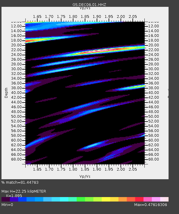
| Estimated Moho Depth: |
22.25 km |
| Estimated Crust Vp/Vs: |
1.89 |
| Assumed Crust Vp: |
6.444 km/s |
| Estimated Crust Vs: |
3.4 km/s |
| Estimated Crust Poisson's Ratio: |
0.31 |
|
| Radial Match: |
81.44763 % |
| Radial Bump: |
400 |
| Transverse Match: |
64.47798 % |
| Transverse Bump: |
400 |
| SOD ConfigId: |
2825771 |
| Insert Time: |
2018-08-31 23:28:49.218 +0000 |
| GWidth: |
2.5 |
| Max Bumps: |
400 |
| Tol: |
0.001 |
|
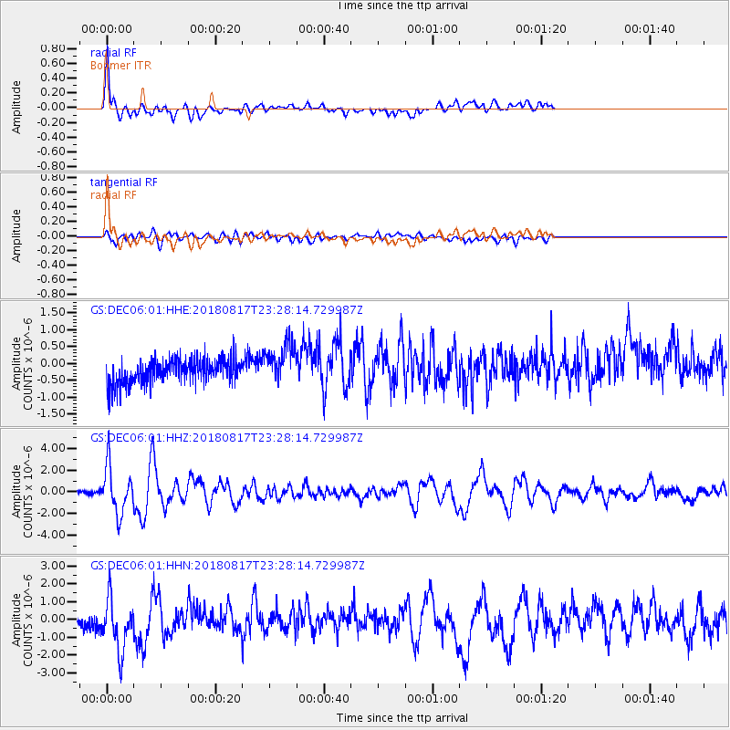
Signal To Noise
| Channel | StoN | STA | LTA |
| GS:DEC06:01:HHZ:20180817T23:28:14.729987Z | 12.934326 | 2.1895698E-6 | 1.6928365E-7 |
| GS:DEC06:01:HHN:20180817T23:28:14.729987Z | 4.72815 | 1.4601645E-6 | 3.0882364E-7 |
| GS:DEC06:01:HHE:20180817T23:28:14.729987Z | 1.6732271 | 6.1134955E-7 | 3.6537156E-7 |
| Arrivals |
| Ps | 3.3 SECOND |
| PpPs | 9.3 SECOND |
| PsPs/PpSs | 13 SECOND |


