You are here: Home > Network List > US - United States National Seismic Network Stations List
> Station GLMI Grayling, Michigan, USA > Earthquake Result Viewer
GLMI Grayling, Michigan, USA - Earthquake Result Viewer
| Earthquake location: |
Hokkaido, Japan Region |
| Earthquake latitude/longitude: |
45.9/142.1 |
| Earthquake time(UTC): |
2022/07/02 (183) 01:59:45 GMT |
| Earthquake Depth: |
322 km |
| Earthquake Magnitude: |
5.8 mww |
| Earthquake Catalog/Contributor: |
NEIC PDE/us |
|
| Network: |
US United States National Seismic Network |
| Station: |
GLMI Grayling, Michigan, USA |
| Lat/Lon: |
44.82 N/84.62 W |
| Elevation: |
387 m |
|
| Distance: |
80.7 deg |
| Az: |
31.682 deg |
| Baz: |
328.965 deg |
| Ray Param: |
0.047258373 |
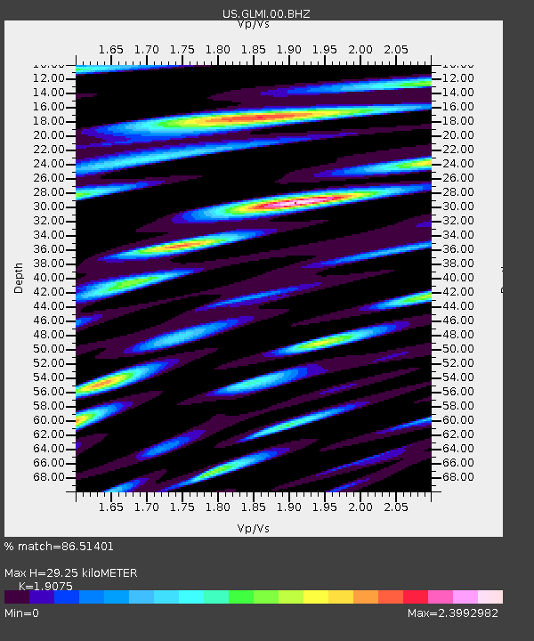
| Estimated Moho Depth: |
29.25 km |
| Estimated Crust Vp/Vs: |
1.91 |
| Assumed Crust Vp: |
6.483 km/s |
| Estimated Crust Vs: |
3.398 km/s |
| Estimated Crust Poisson's Ratio: |
0.31 |
|
| Radial Match: |
86.51401 % |
| Radial Bump: |
400 |
| Transverse Match: |
81.02005 % |
| Transverse Bump: |
400 |
| SOD ConfigId: |
28208852 |
| Insert Time: |
2022-07-16 02:39:40.570 +0000 |
| GWidth: |
2.5 |
| Max Bumps: |
400 |
| Tol: |
0.001 |
|

Signal To Noise
| Channel | StoN | STA | LTA |
| US:GLMI:00:BHZ:20220702T02:10:52.45001Z | 18.155167 | 1.9668578E-6 | 1.0833599E-7 |
| US:GLMI:00:BH1:20220702T02:10:52.45001Z | 6.327859 | 1.3882001E-6 | 2.1937912E-7 |
| US:GLMI:00:BH2:20220702T02:10:52.45001Z | 4.2038283 | 7.713117E-7 | 1.8347842E-7 |
| Arrivals |
| Ps | 4.2 SECOND |
| PpPs | 13 SECOND |
| PsPs/PpSs | 17 SECOND |


