NM26 NewMexico26 - Earthquake Result Viewer
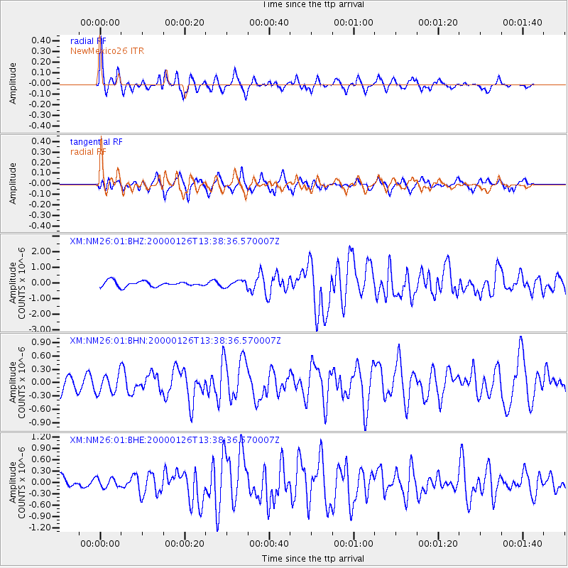
Earthquake location: Tonga Islands
Earthquake latitude/longitude: -17.3/-174.0
Earthquake time(UTC): 2000/01/26 (026) 13:26:50 GMT
Earthquake Depth: 33 km
Earthquake Magnitude: 5.9 MB, 6.0 MS, 6.4 MW, 6.3 MW
Earthquake Catalog/Contributor: WHDF/NEIC
Network: XM Rio Grande Seismic Transect
Station: NM26 NewMexico26
Lat/Lon: 34.26 N/106.36 W
Elevation: 1854 m
Distance: 82.2 deg
Az: 50.632 deg
Baz: 243.109 deg
Ray Param: 0.047006957
Estimated Moho Depth: 38.5 km
Estimated Crust Vp/Vs: 1.70
Assumed Crust Vp: 6.502 km/s
Estimated Crust Vs: 3.83 km/s
Estimated Crust Poisson's Ratio: 0.23
Radial Match: 88.28563 %
Radial Bump: 375
Transverse Match: 74.89122 %
Transverse Bump: 400
SOD ConfigId: 27569
Insert Time: 2010-02-26 17:32:10.628 +0000
GWidth: 2.5
Max Bumps: 400
Tol: 0.001

Signal To Noise

ChannelStoNSTALTA
XM:NM26:01:BHN:20000126T13:38:36.570007Z1.18980672.1540525E-71.8104222E-7
XM:NM26:01:BHE:20000126T13:38:36.570007Z0.611882031.2288523E-72.0083156E-7
XM:NM26:01:BHZ:20000126T13:38:36.570007Z1.23855632.0890556E-71.686686E-7
Arrivals
Ps4.2 SECOND
PpPs16 SECOND
PsPs/PpSs20 SECOND