You are here: Home > Network List > XM99 - Rio Grande Seismic Transect Stations List
> Station NM26 NewMexico26 > Earthquake Result Viewer
NM26 NewMexico26 - Earthquake Result Viewer

| Earthquake location: |
Chile-Bolivia Border Region |
| Earthquake latitude/longitude: |
-21.8/-68.8 |
| Earthquake time(UTC): |
1999/11/21 (325) 03:51:14 GMT |
| Earthquake Depth: |
101 km |
| Earthquake Magnitude: |
5.9 MB, 6.0 MW, 5.8 MW |
| Earthquake Catalog/Contributor: |
WHDF/NEIC |
|
| Network: |
XM Rio Grande Seismic Transect |
| Station: |
NM26 NewMexico26 |
| Lat/Lon: |
34.26 N/106.36 W |
| Elevation: |
1854 m |
|
| Distance: |
66.2 deg |
| Az: |
326.487 deg |
| Baz: |
141.701 deg |
| Ray Param: |
0.057512164 |
| Estimated Moho Depth: |
39.75 km |
| Estimated Crust Vp/Vs: |
1.72 |
| Assumed Crust Vp: |
6.502 km/s |
| Estimated Crust Vs: |
3.791 km/s |
| Estimated Crust Poisson's Ratio: |
0.24 |
|
| Radial Match: |
81.22885 % |
| Radial Bump: |
400 |
| Transverse Match: |
76.35122 % |
| Transverse Bump: |
400 |
| SOD ConfigId: |
27569 |
| Insert Time: |
2010-02-26 17:32:24.505 +0000 |
| GWidth: |
2.5 |
| Max Bumps: |
400 |
| Tol: |
0.001 |
|
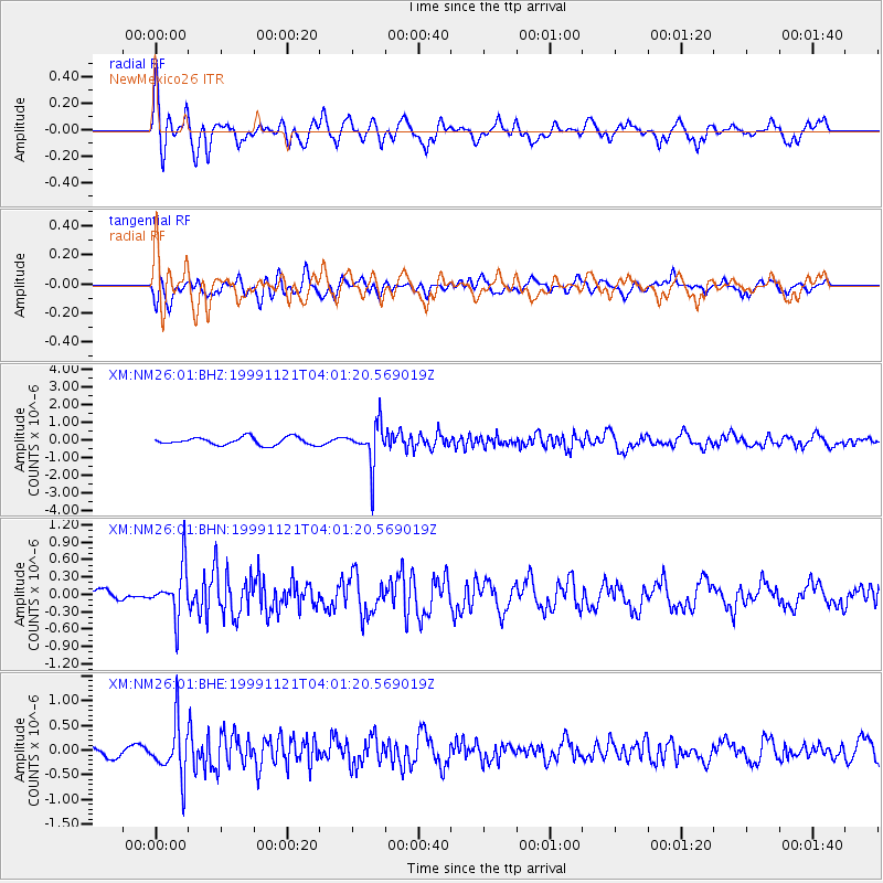
Signal To Noise
| Channel | StoN | STA | LTA |
| XM:NM26:01:BHN:19991121T04:01:20.569019Z | 2.7944736 | 4.290186E-7 | 1.5352394E-7 |
| XM:NM26:01:BHE:19991121T04:01:20.569019Z | 4.113087 | 5.285557E-7 | 1.2850583E-7 |
| XM:NM26:01:BHZ:19991121T04:01:20.569019Z | 5.3239145 | 1.1641578E-6 | 2.1866575E-7 |
| Arrivals |
| Ps | 4.6 SECOND |
| PpPs | 16 SECOND |
| PsPs/PpSs | 20 SECOND |


