You are here: Home > Network List > XM99 - Rio Grande Seismic Transect Stations List
> Station NM26 NewMexico26 > Earthquake Result Viewer
NM26 NewMexico26 - Earthquake Result Viewer

| Earthquake location: |
Kodiak Island Region, Alaska |
| Earthquake latitude/longitude: |
57.4/-154.5 |
| Earthquake time(UTC): |
1999/12/06 (340) 23:12:33 GMT |
| Earthquake Depth: |
66 km |
| Earthquake Magnitude: |
6.8 MB, 7.0 MW, 7.0 ML |
| Earthquake Catalog/Contributor: |
WHDF/NEIC |
|
| Network: |
XM Rio Grande Seismic Transect |
| Station: |
NM26 NewMexico26 |
| Lat/Lon: |
34.26 N/106.36 W |
| Elevation: |
1854 m |
|
| Distance: |
39.6 deg |
| Az: |
104.686 deg |
| Baz: |
320.799 deg |
| Ray Param: |
0.074687235 |
| Estimated Moho Depth: |
38.75 km |
| Estimated Crust Vp/Vs: |
1.73 |
| Assumed Crust Vp: |
6.502 km/s |
| Estimated Crust Vs: |
3.769 km/s |
| Estimated Crust Poisson's Ratio: |
0.25 |
|
| Radial Match: |
96.85295 % |
| Radial Bump: |
400 |
| Transverse Match: |
90.75212 % |
| Transverse Bump: |
400 |
| SOD ConfigId: |
27569 |
| Insert Time: |
2010-02-26 17:32:31.800 +0000 |
| GWidth: |
2.5 |
| Max Bumps: |
400 |
| Tol: |
0.001 |
|
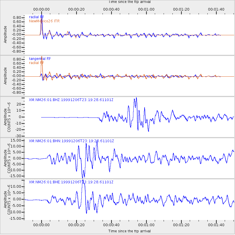
Signal To Noise
| Channel | StoN | STA | LTA |
| XM:NM26:01:BHN:19991206T23:19:28.61101Z | 8.743307 | 1.3596011E-6 | 1.5550192E-7 |
| XM:NM26:01:BHE:19991206T23:19:28.61101Z | 5.6338444 | 1.0206016E-6 | 1.8115544E-7 |
| XM:NM26:01:BHZ:19991206T23:19:28.61101Z | 12.398096 | 2.6206587E-6 | 2.113759E-7 |
| Arrivals |
| Ps | 4.7 SECOND |
| PpPs | 15 SECOND |
| PsPs/PpSs | 20 SECOND |


