You are here: Home > Network List > AK - Alaska Regional Network Stations List
> Station K13K Kusilvak Mountain, AK, USA > Earthquake Result Viewer
K13K Kusilvak Mountain, AK, USA - Earthquake Result Viewer
| Earthquake location: |
Mariana Islands |
| Earthquake latitude/longitude: |
18.8/146.9 |
| Earthquake time(UTC): |
2022/07/08 (189) 16:55:16 GMT |
| Earthquake Depth: |
20 km |
| Earthquake Magnitude: |
5.8 Mi |
| Earthquake Catalog/Contributor: |
NEIC PDE/pt |
|
| Network: |
AK Alaska Regional Network |
| Station: |
K13K Kusilvak Mountain, AK, USA |
| Lat/Lon: |
61.93 N/164.66 W |
| Elevation: |
204 m |
|
| Distance: |
54.6 deg |
| Az: |
25.724 deg |
| Baz: |
240.41 deg |
| Ray Param: |
0.06530409 |
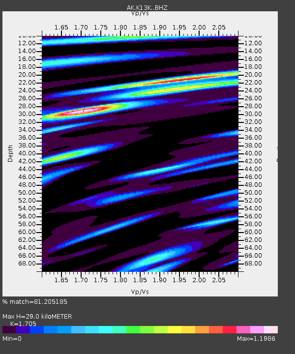
| Estimated Moho Depth: |
29.0 km |
| Estimated Crust Vp/Vs: |
1.71 |
| Assumed Crust Vp: |
6.1 km/s |
| Estimated Crust Vs: |
3.578 km/s |
| Estimated Crust Poisson's Ratio: |
0.24 |
|
| Radial Match: |
81.205185 % |
| Radial Bump: |
307 |
| Transverse Match: |
72.65392 % |
| Transverse Bump: |
400 |
| SOD ConfigId: |
28208852 |
| Insert Time: |
2022-07-22 16:58:26.958 +0000 |
| GWidth: |
2.5 |
| Max Bumps: |
400 |
| Tol: |
0.001 |
|

Signal To Noise
| Channel | StoN | STA | LTA |
| AK:K13K: :BHZ:20220708T17:04:12.299988Z | 2.992555 | 1.6324461E-7 | 5.4550245E-8 |
| AK:K13K: :BHN:20220708T17:04:12.299988Z | 1.2550491 | 5.770809E-8 | 4.5980745E-8 |
| AK:K13K: :BHE:20220708T17:04:12.299988Z | 1.4905684 | 6.1749894E-8 | 4.1427075E-8 |
| Arrivals |
| Ps | 3.5 SECOND |
| PpPs | 12 SECOND |
| PsPs/PpSs | 16 SECOND |


