You are here: Home > Network List > WY - Yellowstone Wyoming Seismic Network Stations List
> Station YTP The Promontory, YNP, WY, USA > Earthquake Result Viewer
YTP The Promontory, YNP, WY, USA - Earthquake Result Viewer
| Earthquake location: |
Costa Rica |
| Earthquake latitude/longitude: |
8.8/-83.2 |
| Earthquake time(UTC): |
2018/08/17 (229) 23:22:24 GMT |
| Earthquake Depth: |
15 km |
| Earthquake Magnitude: |
6.1 Mww |
| Earthquake Catalog/Contributor: |
NEIC PDE/us |
|
| Network: |
WY Yellowstone Wyoming Seismic Network |
| Station: |
YTP The Promontory, YNP, WY, USA |
| Lat/Lon: |
44.39 N/110.29 W |
| Elevation: |
2384 m |
|
| Distance: |
42.6 deg |
| Az: |
331.109 deg |
| Baz: |
138.23 deg |
| Ray Param: |
0.07307729 |
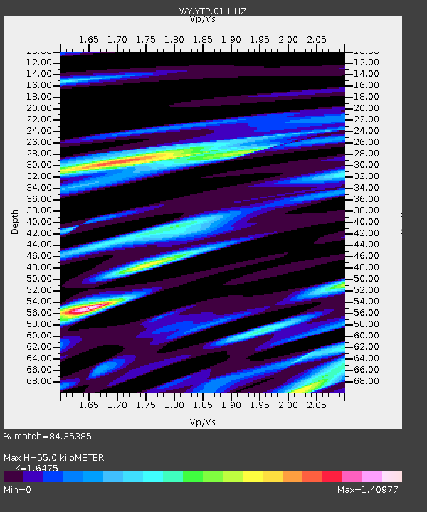
| Estimated Moho Depth: |
55.0 km |
| Estimated Crust Vp/Vs: |
1.65 |
| Assumed Crust Vp: |
6.35 km/s |
| Estimated Crust Vs: |
3.854 km/s |
| Estimated Crust Poisson's Ratio: |
0.21 |
|
| Radial Match: |
84.35385 % |
| Radial Bump: |
400 |
| Transverse Match: |
64.899414 % |
| Transverse Bump: |
400 |
| SOD ConfigId: |
2825771 |
| Insert Time: |
2018-08-31 23:34:06.560 +0000 |
| GWidth: |
2.5 |
| Max Bumps: |
400 |
| Tol: |
0.001 |
|

Signal To Noise
| Channel | StoN | STA | LTA |
| WY:YTP:01:HHZ:20180817T23:29:49.29801Z | 10.150304 | 2.990729E-8 | 2.9464429E-9 |
| WY:YTP:01:HHN:20180817T23:29:49.29801Z | 5.511045 | 1.2613887E-8 | 2.2888376E-9 |
| WY:YTP:01:HHE:20180817T23:29:49.29801Z | 4.537667 | 1.5010404E-8 | 3.3079564E-9 |
| Arrivals |
| Ps | 6.0 SECOND |
| PpPs | 21 SECOND |
| PsPs/PpSs | 27 SECOND |


