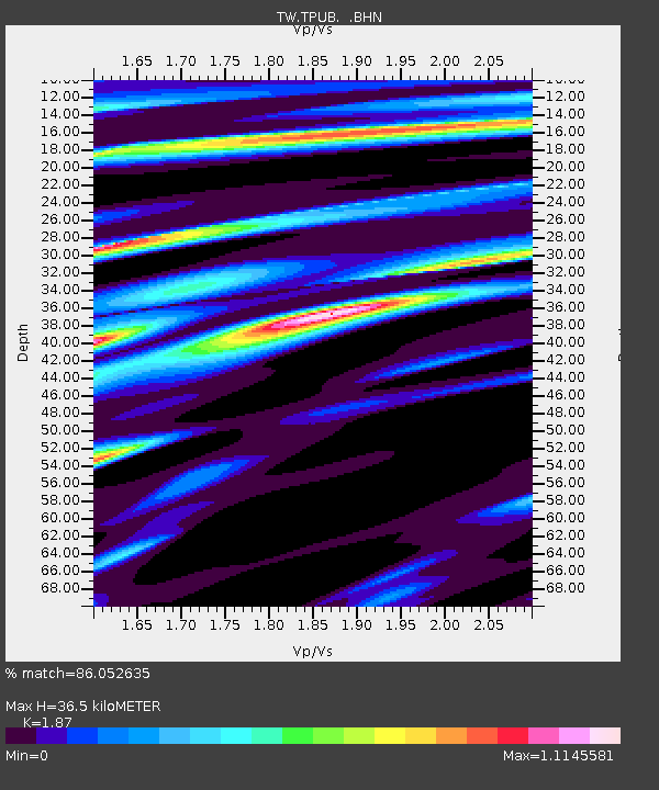
TPUB TA-PU - Earthquake Result Viewer

Earthquake location: Southern Sumatra, Indonesia
Earthquake latitude/longitude: -4.7/102.1
Earthquake time(UTC): 2000/06/04 (156) 16:28:26 GMT
Earthquake Depth: 33 km
Earthquake Magnitude: 6.8 MB, 8.0 MS, 7.9 MW, 7.7 MW
Earthquake Catalog/Contributor: WHDF/NEIC
Network: TW Broadband Array in Taiwan for Seismology
Station: TPUB TA-PU
Lat/Lon: 23.30 N/120.63 E
Elevation: 370 m
Distance: 33.2 deg
Az: 32.257 deg
Baz: 215.35 deg
Ray Param: 0.07825592
Estimated Moho Depth: 36.5 km
Estimated Crust Vp/Vs: 1.87
Assumed Crust Vp: 6.461 km/s
Estimated Crust Vs: 3.455 km/s
Estimated Crust Poisson's Ratio: 0.30
Radial Match: 86.052635 %
Radial Bump: 400
Transverse Match: 74.09727 %
Transverse Bump: 400
SOD ConfigId: 3744
Insert Time: 2010-03-09 22:01:37.554 +0000
GWidth: 2.5
Max Bumps: 400
Tol: 0.001

Signal To Noise

ChannelStoNSTALTA
TW:TPUB: :BHN:20000604T16:34:29.710009Z3.15240361.8443499E-65.8506146E-7
TW:TPUB: :BHE:20000604T16:34:29.710009Z3.23793911.0733702E-63.3149794E-7
TW:TPUB: :BHZ:20000604T16:34:29.710009Z3.26962693.3872634E-61.0359786E-6
Arrivals
Ps5.3 SECOND
PpPs15 SECOND
PsPs/PpSs20 SECOND