You are here: Home > Network List > BK - Berkeley Digital Seismograph Network Stations List
> Station CMB Columbia College, Columbia, CA > Earthquake Result Viewer
CMB Columbia College, Columbia, CA - Earthquake Result Viewer
| Earthquake location: |
Fiji Islands Region |
| Earthquake latitude/longitude: |
-18.2/-178.1 |
| Earthquake time(UTC): |
2018/08/19 (231) 00:19:37 GMT |
| Earthquake Depth: |
563 km |
| Earthquake Magnitude: |
8.2 mww |
| Earthquake Catalog/Contributor: |
NEIC PDE/us |
|
| Network: |
BK Berkeley Digital Seismograph Network |
| Station: |
CMB Columbia College, Columbia, CA |
| Lat/Lon: |
38.03 N/120.39 W |
| Elevation: |
697 m |
|
| Distance: |
77.8 deg |
| Az: |
43.075 deg |
| Baz: |
235.312 deg |
| Ray Param: |
0.048296053 |
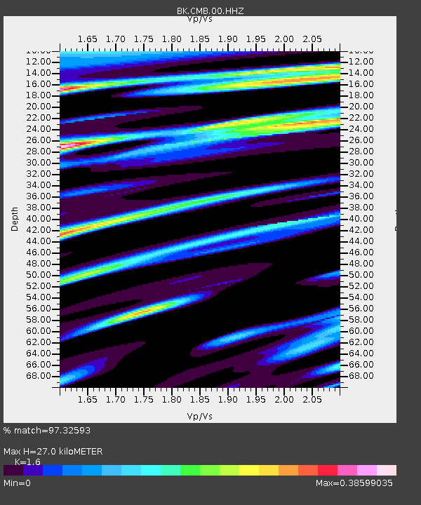
| Estimated Moho Depth: |
27.0 km |
| Estimated Crust Vp/Vs: |
1.60 |
| Assumed Crust Vp: |
6.597 km/s |
| Estimated Crust Vs: |
4.123 km/s |
| Estimated Crust Poisson's Ratio: |
0.18 |
|
| Radial Match: |
97.32593 % |
| Radial Bump: |
400 |
| Transverse Match: |
93.91276 % |
| Transverse Bump: |
400 |
| SOD ConfigId: |
2825771 |
| Insert Time: |
2018-09-02 01:38:54.561 +0000 |
| GWidth: |
2.5 |
| Max Bumps: |
400 |
| Tol: |
0.001 |
|
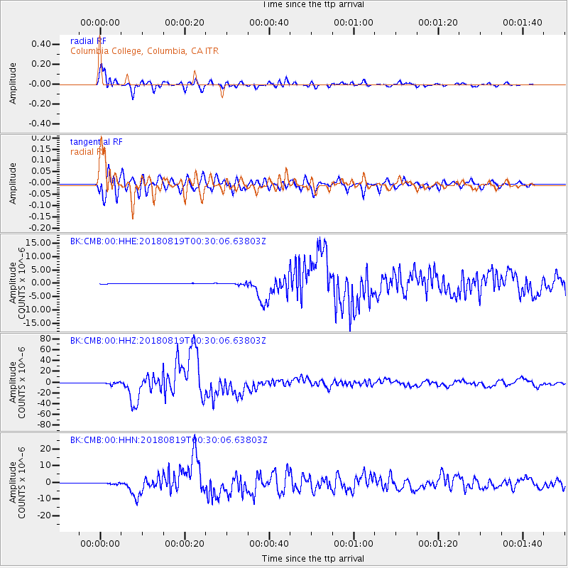
Signal To Noise
| Channel | StoN | STA | LTA |
| BK:CMB:00:HHZ:20180819T00:30:06.63803Z | 5.3934584 | 1.8776619E-6 | 3.4813692E-7 |
| BK:CMB:00:HHN:20180819T00:30:06.63803Z | 2.9526727 | 3.8377857E-7 | 1.2997666E-7 |
| BK:CMB:00:HHE:20180819T00:30:06.63803Z | 4.355316 | 3.3668317E-7 | 7.730396E-8 |
| Arrivals |
| Ps | 2.5 SECOND |
| PpPs | 10 SECOND |
| PsPs/PpSs | 13 SECOND |


