You are here: Home > Network List > UW - Pacific Northwest Regional Seismic Network Stations List
> Station SHW Mt. St. Helens West, WA, USA > Earthquake Result Viewer
SHW Mt. St. Helens West, WA, USA - Earthquake Result Viewer
| Earthquake location: |
Mariana Islands |
| Earthquake latitude/longitude: |
18.8/146.9 |
| Earthquake time(UTC): |
2022/07/08 (189) 16:55:16 GMT |
| Earthquake Depth: |
20 km |
| Earthquake Magnitude: |
5.8 Mi |
| Earthquake Catalog/Contributor: |
NEIC PDE/pt |
|
| Network: |
UW Pacific Northwest Regional Seismic Network |
| Station: |
SHW Mt. St. Helens West, WA, USA |
| Lat/Lon: |
46.19 N/122.23 W |
| Elevation: |
1442 m |
|
| Distance: |
77.3 deg |
| Az: |
45.397 deg |
| Baz: |
283.774 deg |
| Ray Param: |
0.05039952 |
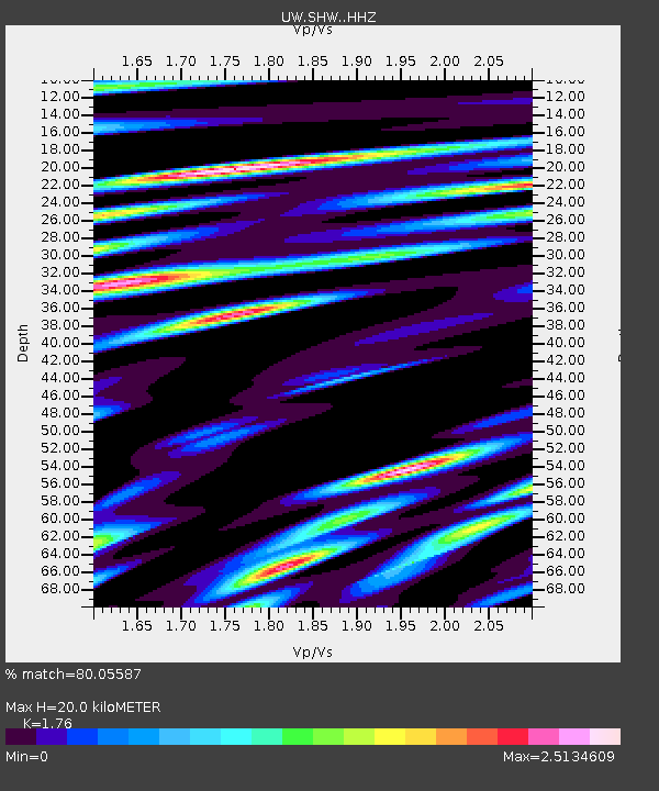
| Estimated Moho Depth: |
20.0 km |
| Estimated Crust Vp/Vs: |
1.76 |
| Assumed Crust Vp: |
6.566 km/s |
| Estimated Crust Vs: |
3.731 km/s |
| Estimated Crust Poisson's Ratio: |
0.26 |
|
| Radial Match: |
80.05587 % |
| Radial Bump: |
400 |
| Transverse Match: |
79.05935 % |
| Transverse Bump: |
400 |
| SOD ConfigId: |
28208852 |
| Insert Time: |
2022-07-22 17:17:42.518 +0000 |
| GWidth: |
2.5 |
| Max Bumps: |
400 |
| Tol: |
0.001 |
|

Signal To Noise
| Channel | StoN | STA | LTA |
| UW:SHW: :HHZ:20220708T17:06:37.700012Z | 2.8702273 | 2.036989E-7 | 7.0969605E-8 |
| UW:SHW: :HHN:20220708T17:06:37.700012Z | 1.0210041 | 1.1771894E-7 | 1.15297226E-7 |
| UW:SHW: :HHE:20220708T17:06:37.700012Z | 2.483699 | 1.6458733E-7 | 6.626702E-8 |
| Arrivals |
| Ps | 2.4 SECOND |
| PpPs | 8.1 SECOND |
| PsPs/PpSs | 11 SECOND |


