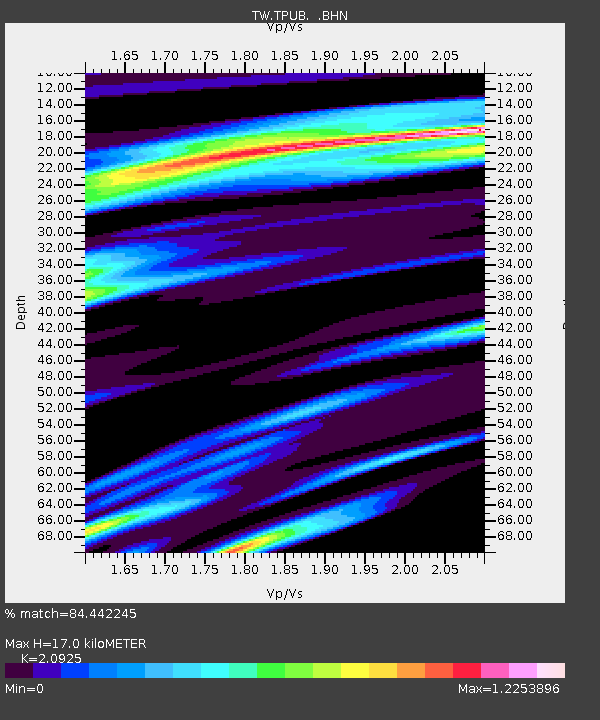
TPUB TA-PU - Earthquake Result Viewer

Earthquake location: Solomon Islands
Earthquake latitude/longitude: -7.4/155.9
Earthquake time(UTC): 2001/04/19 (109) 21:43:42 GMT
Earthquake Depth: 17 km
Earthquake Magnitude: 6.0 MB, 6.6 MS, 6.7 MW, 6.2 ME
Earthquake Catalog/Contributor: WHDF/NEIC
Network: TW Broadband Array in Taiwan for Seismology
Station: TPUB TA-PU
Lat/Lon: 23.30 N/120.63 E
Elevation: 370 m
Distance: 46.0 deg
Az: 312.514 deg
Baz: 127.333 deg
Ray Param: 0.07088413
Estimated Moho Depth: 17.0 km
Estimated Crust Vp/Vs: 2.09
Assumed Crust Vp: 6.461 km/s
Estimated Crust Vs: 3.088 km/s
Estimated Crust Poisson's Ratio: 0.35
Radial Match: 84.442245 %
Radial Bump: 400
Transverse Match: 82.46132 %
Transverse Bump: 400
SOD ConfigId: 4714
Insert Time: 2010-03-09 22:01:58.467 +0000
GWidth: 2.5
Max Bumps: 400
Tol: 0.001

Signal To Noise

ChannelStoNSTALTA
TW:TPUB: :BHN:20010419T21:51:33.902009Z1.78954295.933755E-73.3157937E-7
TW:TPUB: :BHE:20010419T21:51:33.902009Z2.23225716.5513956E-72.934875E-7
TW:TPUB: :BHZ:20010419T21:51:33.902009Z7.03289751.9530694E-62.7770477E-7
Arrivals
Ps3.0 SECOND
PpPs7.7 SECOND
PsPs/PpSs11 SECOND