You are here: Home > Network List > AK - Alaska Regional Network Stations List
> Station JIS Juneau Island, AK, USA > Earthquake Result Viewer
JIS Juneau Island, AK, USA - Earthquake Result Viewer
| Earthquake location: |
Mariana Islands |
| Earthquake latitude/longitude: |
18.8/146.8 |
| Earthquake time(UTC): |
2022/07/08 (189) 23:36:11 GMT |
| Earthquake Depth: |
23 km |
| Earthquake Magnitude: |
6.3 Mi |
| Earthquake Catalog/Contributor: |
NEIC PDE/pt |
|
| Network: |
AK Alaska Regional Network |
| Station: |
JIS Juneau Island, AK, USA |
| Lat/Lon: |
58.28 N/134.38 W |
| Elevation: |
10 m |
|
| Distance: |
68.3 deg |
| Az: |
33.901 deg |
| Baz: |
270.85 deg |
| Ray Param: |
0.056338117 |
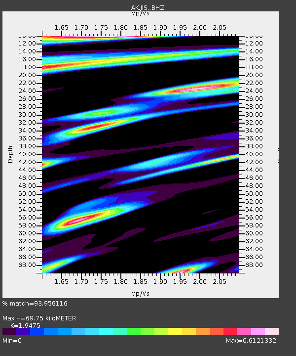
| Estimated Moho Depth: |
69.75 km |
| Estimated Crust Vp/Vs: |
1.95 |
| Assumed Crust Vp: |
6.566 km/s |
| Estimated Crust Vs: |
3.372 km/s |
| Estimated Crust Poisson's Ratio: |
0.32 |
|
| Radial Match: |
93.956116 % |
| Radial Bump: |
400 |
| Transverse Match: |
84.880135 % |
| Transverse Bump: |
400 |
| SOD ConfigId: |
28208852 |
| Insert Time: |
2022-07-22 23:41:20.911 +0000 |
| GWidth: |
2.5 |
| Max Bumps: |
400 |
| Tol: |
0.001 |
|

Signal To Noise
| Channel | StoN | STA | LTA |
| AK:JIS: :BHZ:20220708T23:46:39.288025Z | 11.9624815 | 6.722206E-7 | 5.6194082E-8 |
| AK:JIS: :BHN:20220708T23:46:39.288025Z | 1.4364597 | 6.248877E-8 | 4.350193E-8 |
| AK:JIS: :BHE:20220708T23:46:39.288025Z | 6.016297 | 2.958092E-7 | 4.9167987E-8 |
| Arrivals |
| Ps | 10 SECOND |
| PpPs | 30 SECOND |
| PsPs/PpSs | 41 SECOND |


