You are here: Home > Network List > AK - Alaska Regional Network Stations List
> Station L20K Alaska Regional Network > Earthquake Result Viewer
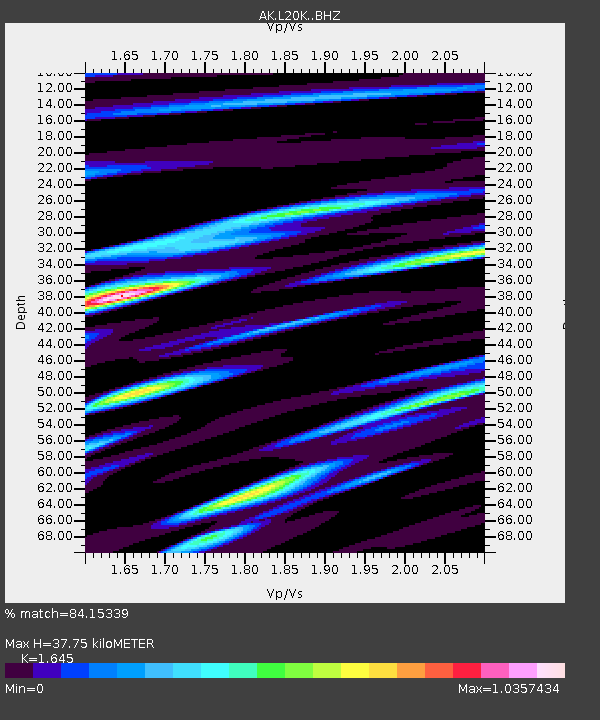
L20K Alaska Regional Network - Earthquake Result Viewer
| Earthquake location: |
Mariana Islands |
| Earthquake latitude/longitude: |
18.8/146.8 |
| Earthquake time(UTC): |
2022/07/08 (189) 23:36:11 GMT |
| Earthquake Depth: |
23 km |
| Earthquake Magnitude: |
6.3 Mi |
| Earthquake Catalog/Contributor: |
NEIC PDE/pt |
|
| Network: |
AK Alaska Regional Network |
| Station: |
L20K Alaska Regional Network |
| Lat/Lon: |
62.48 N/153.88 W |
| Elevation: |
673 m |
|
| Distance: |
59.5 deg |
| Az: |
27.646 deg |
| Baz: |
251.115 deg |
| Ray Param: |
0.062149405 |
| Estimated Moho Depth: |
37.75 km |
| Estimated Crust Vp/Vs: |
1.64 |
| Assumed Crust Vp: |
6.566 km/s |
| Estimated Crust Vs: |
3.992 km/s |
| Estimated Crust Poisson's Ratio: |
0.21 |
|
| Radial Match: |
84.15339 % |
| Radial Bump: |
400 |
| Transverse Match: |
70.0712 % |
| Transverse Bump: |
400 |
| SOD ConfigId: |
28208852 |
| Insert Time: |
2022-07-22 23:41:38.441 +0000 |
| GWidth: |
2.5 |
| Max Bumps: |
400 |
| Tol: |
0.001 |
|

Signal To Noise
| Channel | StoN | STA | LTA |
| AK:L20K: :BHZ:20220708T23:45:40.919983Z | 8.386159 | 8.567495E-7 | 1.02162325E-7 |
| AK:L20K: :BHN:20220708T23:45:40.919983Z | 2.1073537 | 2.1289625E-7 | 1.010254E-7 |
| AK:L20K: :BHE:20220708T23:45:40.919983Z | 3.9209478 | 5.8381283E-7 | 1.4889585E-7 |
| Arrivals |
| Ps | 3.9 SECOND |
| PpPs | 14 SECOND |
| PsPs/PpSs | 18 SECOND |


