You are here: Home > Network List > GS - US Geological Survey Networks Stations List
> Station KAN14 Manchester OK Station > Earthquake Result Viewer
KAN14 Manchester OK Station - Earthquake Result Viewer
| Earthquake location: |
Fiji Islands Region |
| Earthquake latitude/longitude: |
-18.2/-178.1 |
| Earthquake time(UTC): |
2018/08/19 (231) 00:19:37 GMT |
| Earthquake Depth: |
563 km |
| Earthquake Magnitude: |
8.2 mww |
| Earthquake Catalog/Contributor: |
NEIC PDE/us |
|
| Network: |
GS US Geological Survey Networks |
| Station: |
KAN14 Manchester OK Station |
| Lat/Lon: |
36.96 N/97.96 W |
| Elevation: |
363 m |
|
| Distance: |
93.2 deg |
| Az: |
52.225 deg |
| Baz: |
249.739 deg |
| Ray Param: |
0.04082775 |
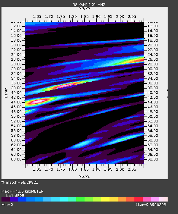
| Estimated Moho Depth: |
43.5 km |
| Estimated Crust Vp/Vs: |
1.65 |
| Assumed Crust Vp: |
6.483 km/s |
| Estimated Crust Vs: |
3.923 km/s |
| Estimated Crust Poisson's Ratio: |
0.21 |
|
| Radial Match: |
96.29921 % |
| Radial Bump: |
400 |
| Transverse Match: |
77.76974 % |
| Transverse Bump: |
400 |
| SOD ConfigId: |
2825771 |
| Insert Time: |
2018-09-02 01:39:56.016 +0000 |
| GWidth: |
2.5 |
| Max Bumps: |
400 |
| Tol: |
0.001 |
|

Signal To Noise
| Channel | StoN | STA | LTA |
| GS:KAN14:01:HHZ:20180819T00:31:20.959014Z | 10.378948 | 8.143046E-7 | 7.845733E-8 |
| GS:KAN14:01:HHN:20180819T00:31:20.959014Z | 1.3644199 | 1.7459597E-7 | 1.2796352E-7 |
| GS:KAN14:01:HHE:20180819T00:31:20.959014Z | 3.210691 | 2.4294778E-7 | 7.566838E-8 |
| Arrivals |
| Ps | 4.5 SECOND |
| PpPs | 17 SECOND |
| PsPs/PpSs | 22 SECOND |


