You are here: Home > Network List > IU - Global Seismograph Network (GSN - IRIS/USGS) Stations List
> Station PAYG Puerto Ayora, Galapagos Islands > Earthquake Result Viewer
PAYG Puerto Ayora, Galapagos Islands - Earthquake Result Viewer
| Earthquake location: |
Fiji Islands Region |
| Earthquake latitude/longitude: |
-18.2/-178.1 |
| Earthquake time(UTC): |
2018/08/19 (231) 00:19:37 GMT |
| Earthquake Depth: |
563 km |
| Earthquake Magnitude: |
8.2 mww |
| Earthquake Catalog/Contributor: |
NEIC PDE/us |
|
| Network: |
IU Global Seismograph Network (GSN - IRIS/USGS) |
| Station: |
PAYG Puerto Ayora, Galapagos Islands |
| Lat/Lon: |
0.67 S/90.29 W |
| Elevation: |
270 m |
|
| Distance: |
87.7 deg |
| Az: |
89.962 deg |
| Baz: |
251.948 deg |
| Ray Param: |
0.04171362 |
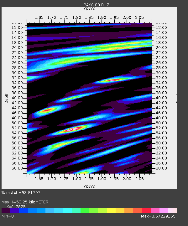
| Estimated Moho Depth: |
52.25 km |
| Estimated Crust Vp/Vs: |
1.78 |
| Assumed Crust Vp: |
4.802 km/s |
| Estimated Crust Vs: |
2.694 km/s |
| Estimated Crust Poisson's Ratio: |
0.27 |
|
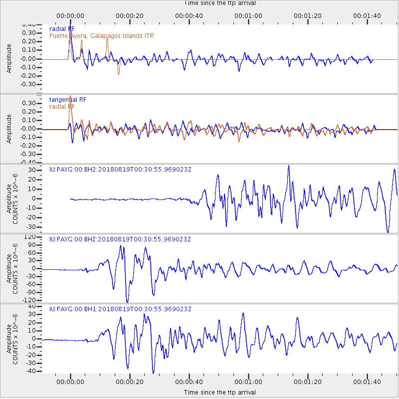
| Radial Match: |
93.81797 % |
| Radial Bump: |
400 |
| Transverse Match: |
83.54856 % |
| Transverse Bump: |
400 |
| SOD ConfigId: |
2825771 |
| Insert Time: |
2018-09-02 01:41:02.670 +0000 |
| GWidth: |
2.5 |
| Max Bumps: |
400 |
| Tol: |
0.001 |
|
Signal To Noise
| Channel | StoN | STA | LTA |
| IU:PAYG:00:BHZ:20180819T00:30:55.969023Z | 4.5938554 | 2.7242106E-6 | 5.9301186E-7 |
| IU:PAYG:00:BH1:20180819T00:30:55.969023Z | 3.187943 | 1.182103E-6 | 3.708043E-7 |
| IU:PAYG:00:BH2:20180819T00:30:55.969023Z | 1.5471154 | 5.7629495E-7 | 3.724964E-7 |
| Arrivals |
| Ps | 8.6 SECOND |
| PpPs | 30 SECOND |
| PsPs/PpSs | 39 SECOND |


