You are here: Home > Network List > CN - Canadian National Seismograph Network Stations List
> Station BPEB Brooks Peninsula, BC, CA > Earthquake Result Viewer
BPEB Brooks Peninsula, BC, CA - Earthquake Result Viewer
| Earthquake location: |
Mariana Islands |
| Earthquake latitude/longitude: |
18.8/146.8 |
| Earthquake time(UTC): |
2022/07/08 (189) 23:36:11 GMT |
| Earthquake Depth: |
23 km |
| Earthquake Magnitude: |
6.3 Mi |
| Earthquake Catalog/Contributor: |
NEIC PDE/pt |
|
| Network: |
CN Canadian National Seismograph Network |
| Station: |
BPEB Brooks Peninsula, BC, CA |
| Lat/Lon: |
50.16 N/127.77 W |
| Elevation: |
737 m |
|
| Distance: |
72.9 deg |
| Az: |
42.129 deg |
| Baz: |
278.951 deg |
| Ray Param: |
0.053330228 |
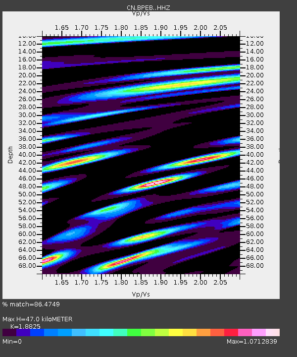
| Estimated Moho Depth: |
47.0 km |
| Estimated Crust Vp/Vs: |
1.88 |
| Assumed Crust Vp: |
6.545 km/s |
| Estimated Crust Vs: |
3.477 km/s |
| Estimated Crust Poisson's Ratio: |
0.30 |
|
| Radial Match: |
86.4749 % |
| Radial Bump: |
400 |
| Transverse Match: |
77.21095 % |
| Transverse Bump: |
400 |
| SOD ConfigId: |
28208852 |
| Insert Time: |
2022-07-22 23:53:09.933 +0000 |
| GWidth: |
2.5 |
| Max Bumps: |
400 |
| Tol: |
0.001 |
|

Signal To Noise
| Channel | StoN | STA | LTA |
| CN:BPEB: :HHZ:20220708T23:47:07.070007Z | 17.077148 | 9.555101E-7 | 5.5952555E-8 |
| CN:BPEB: :HHN:20220708T23:47:07.070007Z | 2.4742124 | 2.5641262E-7 | 1.0363403E-7 |
| CN:BPEB: :HHE:20220708T23:47:07.070007Z | 3.5786645 | 4.2170336E-7 | 1.1783819E-7 |
| Arrivals |
| Ps | 6.6 SECOND |
| PpPs | 20 SECOND |
| PsPs/PpSs | 27 SECOND |


