You are here: Home > Network List > IU - Global Seismograph Network (GSN - IRIS/USGS) Stations List
> Station ULN Ulaanbaatar, Mongolia > Earthquake Result Viewer
ULN Ulaanbaatar, Mongolia - Earthquake Result Viewer
| Earthquake location: |
Fiji Islands Region |
| Earthquake latitude/longitude: |
-18.2/-178.1 |
| Earthquake time(UTC): |
2018/08/19 (231) 00:19:37 GMT |
| Earthquake Depth: |
563 km |
| Earthquake Magnitude: |
8.2 mww |
| Earthquake Catalog/Contributor: |
NEIC PDE/us |
|
| Network: |
IU Global Seismograph Network (GSN - IRIS/USGS) |
| Station: |
ULN Ulaanbaatar, Mongolia |
| Lat/Lon: |
47.87 N/107.05 E |
| Elevation: |
1610 m |
|
| Distance: |
93.5 deg |
| Az: |
319.371 deg |
| Baz: |
113.167 deg |
| Ray Param: |
0.040730666 |
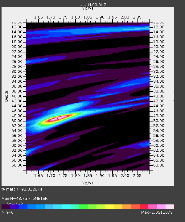
| Estimated Moho Depth: |
48.75 km |
| Estimated Crust Vp/Vs: |
1.73 |
| Assumed Crust Vp: |
6.642 km/s |
| Estimated Crust Vs: |
3.85 km/s |
| Estimated Crust Poisson's Ratio: |
0.25 |
|
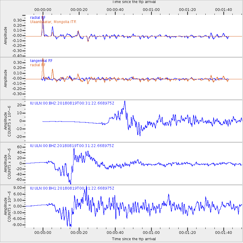
| Radial Match: |
98.312874 % |
| Radial Bump: |
400 |
| Transverse Match: |
83.61998 % |
| Transverse Bump: |
400 |
| SOD ConfigId: |
2825771 |
| Insert Time: |
2018-09-02 01:41:23.256 +0000 |
| GWidth: |
2.5 |
| Max Bumps: |
400 |
| Tol: |
0.001 |
|
Signal To Noise
| Channel | StoN | STA | LTA |
| IU:ULN:00:BHZ:20180819T00:31:22.668975Z | 4.5977206 | 6.022314E-6 | 1.3098478E-6 |
| IU:ULN:00:BH1:20180819T00:31:22.668975Z | 5.8331523 | 9.690839E-7 | 1.6613382E-7 |
| IU:ULN:00:BH2:20180819T00:31:22.668975Z | 5.759397 | 2.3245605E-6 | 4.0361178E-7 |
| Arrivals |
| Ps | 5.4 SECOND |
| PpPs | 20 SECOND |
| PsPs/PpSs | 25 SECOND |


