You are here: Home > Network List > IU - Global Seismograph Network (GSN - IRIS/USGS) Stations List
> Station HKT Hockley, Texas > Earthquake Result Viewer
HKT Hockley, Texas - Earthquake Result Viewer
| Earthquake location: |
Fiji Islands Region |
| Earthquake latitude/longitude: |
-18.2/-178.1 |
| Earthquake time(UTC): |
2018/08/19 (231) 00:19:37 GMT |
| Earthquake Depth: |
563 km |
| Earthquake Magnitude: |
8.2 mww |
| Earthquake Catalog/Contributor: |
NEIC PDE/us |
|
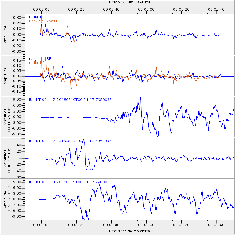
| Network: |
IU Global Seismograph Network (GSN - IRIS/USGS) |
| Station: |
HKT Hockley, Texas |
| Lat/Lon: |
29.96 N/95.84 W |
| Elevation: |
69 m |
|
| Distance: |
92.5 deg |
| Az: |
59.395 deg |
| Baz: |
250.554 deg |
| Ray Param: |
0.04100999 |
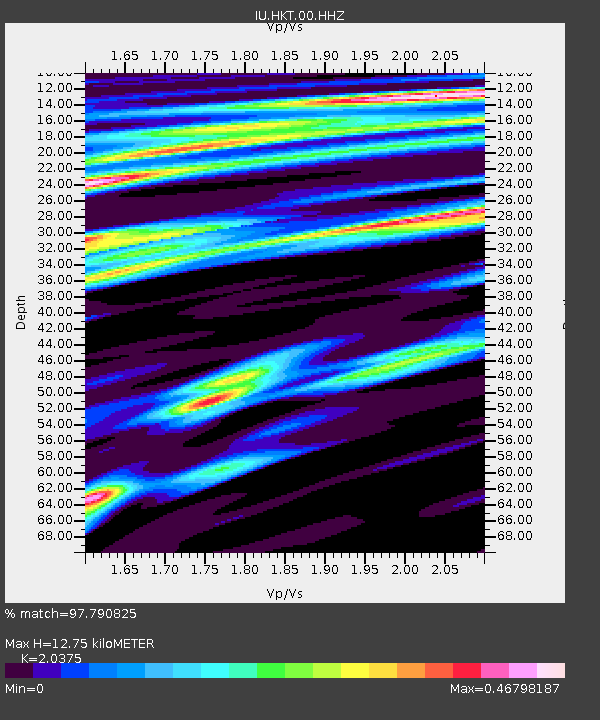
| Estimated Moho Depth: |
12.75 km |
| Estimated Crust Vp/Vs: |
2.04 |
| Assumed Crust Vp: |
5.581 km/s |
| Estimated Crust Vs: |
2.739 km/s |
| Estimated Crust Poisson's Ratio: |
0.34 |
|
| Radial Match: |
97.790825 % |
| Radial Bump: |
357 |
| Transverse Match: |
96.34959 % |
| Transverse Bump: |
400 |
| SOD ConfigId: |
2825771 |
| Insert Time: |
2018-09-02 01:41:30.251 +0000 |
| GWidth: |
2.5 |
| Max Bumps: |
400 |
| Tol: |
0.001 |
|
Signal To Noise
| Channel | StoN | STA | LTA |
| IU:HKT:00:HHZ:20180819T00:31:17.798003Z | 11.666589 | 1.3272763E-6 | 1.137673E-7 |
| IU:HKT:00:HH1:20180819T00:31:17.798003Z | 4.4050384 | 3.5603676E-7 | 8.08249E-8 |
| IU:HKT:00:HH2:20180819T00:31:17.798003Z | 7.313381 | 3.3235503E-7 | 4.5444786E-8 |
| Arrivals |
| Ps | 2.4 SECOND |
| PpPs | 6.8 SECOND |
| PsPs/PpSs | 9.2 SECOND |


