You are here: Home > Network List > IM - International Miscellaneous Stations Stations List
> Station SHEM Shemya Island, Alaska, USA > Earthquake Result Viewer
SHEM Shemya Island, Alaska, USA - Earthquake Result Viewer
| Earthquake location: |
Mariana Islands |
| Earthquake latitude/longitude: |
18.8/146.8 |
| Earthquake time(UTC): |
2022/07/08 (189) 23:36:11 GMT |
| Earthquake Depth: |
23 km |
| Earthquake Magnitude: |
6.3 Mi |
| Earthquake Catalog/Contributor: |
NEIC PDE/pt |
|
| Network: |
IM International Miscellaneous Stations |
| Station: |
SHEM Shemya Island, Alaska, USA |
| Lat/Lon: |
52.73 N/174.10 E |
| Elevation: |
580 m |
|
| Distance: |
40.0 deg |
| Az: |
25.753 deg |
| Baz: |
222.589 deg |
| Ray Param: |
0.07462656 |
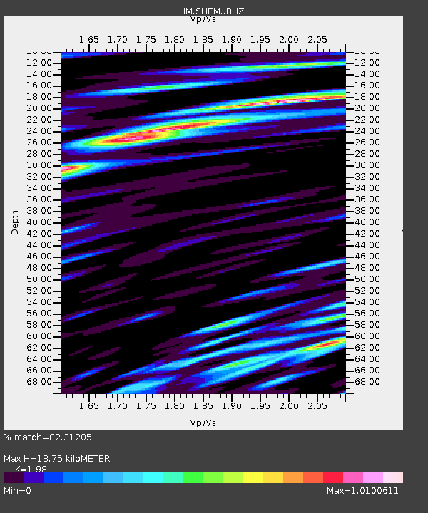
| Estimated Moho Depth: |
18.75 km |
| Estimated Crust Vp/Vs: |
1.98 |
| Assumed Crust Vp: |
3.999 km/s |
| Estimated Crust Vs: |
2.019 km/s |
| Estimated Crust Poisson's Ratio: |
0.33 |
|
| Radial Match: |
82.31205 % |
| Radial Bump: |
400 |
| Transverse Match: |
71.20171 % |
| Transverse Bump: |
400 |
| SOD ConfigId: |
28208852 |
| Insert Time: |
2022-07-22 23:57:25.286 +0000 |
| GWidth: |
2.5 |
| Max Bumps: |
400 |
| Tol: |
0.001 |
|

Signal To Noise
| Channel | StoN | STA | LTA |
| IM:SHEM: :BHZ:20220708T23:43:13.000Z | 3.8498447 | 1.244202E-6 | 3.231824E-7 |
| IM:SHEM: :BHN:20220708T23:43:13.000Z | 1.1666071 | 4.6969967E-7 | 4.0262023E-7 |
| IM:SHEM: :BHE:20220708T23:43:13.000Z | 1.1972123 | 7.587176E-7 | 6.337369E-7 |
| Arrivals |
| Ps | 4.7 SECOND |
| PpPs | 14 SECOND |
| PsPs/PpSs | 18 SECOND |


