You are here: Home > Network List > UU - University of Utah Regional Network Stations List
> Station CCUT Cedar City, UT, USA > Earthquake Result Viewer
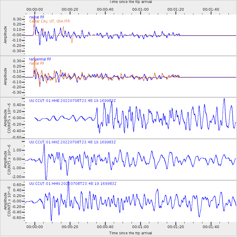
CCUT Cedar City, UT, USA - Earthquake Result Viewer

| Earthquake location: |
Mariana Islands |
| Earthquake latitude/longitude: |
18.8/146.8 |
| Earthquake time(UTC): |
2022/07/08 (189) 23:36:11 GMT |
| Earthquake Depth: |
23 km |
| Earthquake Magnitude: |
6.3 Mi |
| Earthquake Catalog/Contributor: |
NEIC PDE/pt |
|
| Network: |
UU University of Utah Regional Network |
| Station: |
CCUT Cedar City, UT, USA |
| Lat/Lon: |
37.55 N/113.36 W |
| Elevation: |
2127 m |
|
| Distance: |
86.2 deg |
| Az: |
51.696 deg |
| Baz: |
290.734 deg |
| Ray Param: |
0.044174686 |
| Estimated Moho Depth: |
10.0 km |
| Estimated Crust Vp/Vs: |
1.72 |
| Assumed Crust Vp: |
6.194 km/s |
| Estimated Crust Vs: |
3.607 km/s |
| Estimated Crust Poisson's Ratio: |
0.24 |
|
| Radial Match: |
88.58567 % |
| Radial Bump: |
400 |
| Transverse Match: |
88.83095 % |
| Transverse Bump: |
400 |
| SOD ConfigId: |
28208852 |
| Insert Time: |
2022-07-23 00:06:49.839 +0000 |
| GWidth: |
2.5 |
| Max Bumps: |
400 |
| Tol: |
0.001 |
|
Signal To Noise
| Channel | StoN | STA | LTA |
| UU:CCUT:01:HHZ:20220708T23:48:19.169983Z | 3.8430731 | 1.7900561E-7 | 4.6578766E-8 |
| UU:CCUT:01:HHN:20220708T23:48:19.169983Z | 1.0559177 | 5.0050435E-8 | 4.7399936E-8 |
| UU:CCUT:01:HHE:20220708T23:48:19.169983Z | 0.91449684 | 4.116496E-8 | 4.501378E-8 |
| Arrivals |
| Ps | 1.2 SECOND |
| PpPs | 4.3 SECOND |
| PsPs/PpSs | 5.5 SECOND |


