You are here: Home > Network List > UU - University of Utah Regional Network Stations List
> Station CTU Camp Tracy, UT, USA > Earthquake Result Viewer
CTU Camp Tracy, UT, USA - Earthquake Result Viewer
| Earthquake location: |
Mariana Islands |
| Earthquake latitude/longitude: |
18.8/146.8 |
| Earthquake time(UTC): |
2022/07/08 (189) 23:36:11 GMT |
| Earthquake Depth: |
23 km |
| Earthquake Magnitude: |
6.3 Mi |
| Earthquake Catalog/Contributor: |
NEIC PDE/pt |
|
| Network: |
UU University of Utah Regional Network |
| Station: |
CTU Camp Tracy, UT, USA |
| Lat/Lon: |
40.69 N/111.75 W |
| Elevation: |
1731 m |
|
| Distance: |
86.3 deg |
| Az: |
48.31 deg |
| Baz: |
291.527 deg |
| Ray Param: |
0.044146344 |
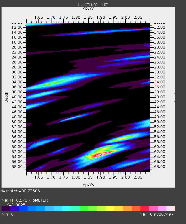
| Estimated Moho Depth: |
62.75 km |
| Estimated Crust Vp/Vs: |
1.90 |
| Assumed Crust Vp: |
6.155 km/s |
| Estimated Crust Vs: |
3.235 km/s |
| Estimated Crust Poisson's Ratio: |
0.31 |
|
| Radial Match: |
88.77506 % |
| Radial Bump: |
400 |
| Transverse Match: |
89.48389 % |
| Transverse Bump: |
400 |
| SOD ConfigId: |
28208852 |
| Insert Time: |
2022-07-23 00:06:50.546 +0000 |
| GWidth: |
2.5 |
| Max Bumps: |
400 |
| Tol: |
0.001 |
|

Signal To Noise
| Channel | StoN | STA | LTA |
| UU:CTU:01:HHZ:20220708T23:48:19.359985Z | 12.370381 | 9.09607E-9 | 7.3531037E-10 |
| UU:CTU:01:HHN:20220708T23:48:19.359985Z | 1.5506035 | 1.3742374E-9 | 8.862597E-10 |
| UU:CTU:01:HHE:20220708T23:48:19.359985Z | 2.8103902 | 3.2887064E-9 | 1.1701956E-9 |
| Arrivals |
| Ps | 9.4 SECOND |
| PpPs | 29 SECOND |
| PsPs/PpSs | 38 SECOND |


