You are here: Home > Network List > UU - University of Utah Regional Network Stations List
> Station MOUT Mount Ogden, UT, USA > Earthquake Result Viewer
MOUT Mount Ogden, UT, USA - Earthquake Result Viewer
| Earthquake location: |
Mariana Islands |
| Earthquake latitude/longitude: |
18.8/146.8 |
| Earthquake time(UTC): |
2022/07/08 (189) 23:36:11 GMT |
| Earthquake Depth: |
23 km |
| Earthquake Magnitude: |
6.3 Mi |
| Earthquake Catalog/Contributor: |
NEIC PDE/pt |
|
| Network: |
UU University of Utah Regional Network |
| Station: |
MOUT Mount Ogden, UT, USA |
| Lat/Lon: |
41.20 N/111.88 W |
| Elevation: |
2748 m |
|
| Distance: |
86.0 deg |
| Az: |
47.874 deg |
| Baz: |
291.413 deg |
| Ray Param: |
0.04434483 |
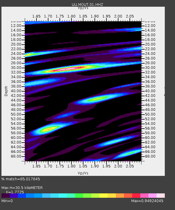
| Estimated Moho Depth: |
30.5 km |
| Estimated Crust Vp/Vs: |
1.77 |
| Assumed Crust Vp: |
6.155 km/s |
| Estimated Crust Vs: |
3.472 km/s |
| Estimated Crust Poisson's Ratio: |
0.27 |
|
| Radial Match: |
85.017845 % |
| Radial Bump: |
400 |
| Transverse Match: |
84.3765 % |
| Transverse Bump: |
400 |
| SOD ConfigId: |
28208852 |
| Insert Time: |
2022-07-23 00:07:08.539 +0000 |
| GWidth: |
2.5 |
| Max Bumps: |
400 |
| Tol: |
0.001 |
|

Signal To Noise
| Channel | StoN | STA | LTA |
| UU:MOUT:01:HHZ:20220708T23:48:18.01001Z | 9.785778 | 7.5603E-7 | 7.7258036E-8 |
| UU:MOUT:01:HHN:20220708T23:48:18.01001Z | 1.849308 | 1.1720777E-7 | 6.3379254E-8 |
| UU:MOUT:01:HHE:20220708T23:48:18.01001Z | 3.5995247 | 3.0478054E-7 | 8.4672436E-8 |
| Arrivals |
| Ps | 3.9 SECOND |
| PpPs | 13 SECOND |
| PsPs/PpSs | 17 SECOND |


