You are here: Home > Network List > UW - Pacific Northwest Regional Seismic Network Stations List
> Station MANO Manastash Observatory, WA, USA > Earthquake Result Viewer
MANO Manastash Observatory, WA, USA - Earthquake Result Viewer
| Earthquake location: |
Mariana Islands |
| Earthquake latitude/longitude: |
18.8/146.8 |
| Earthquake time(UTC): |
2022/07/08 (189) 23:36:11 GMT |
| Earthquake Depth: |
23 km |
| Earthquake Magnitude: |
6.3 Mi |
| Earthquake Catalog/Contributor: |
NEIC PDE/pt |
|
| Network: |
UW Pacific Northwest Regional Seismic Network |
| Station: |
MANO Manastash Observatory, WA, USA |
| Lat/Lon: |
46.95 N/120.72 W |
| Elevation: |
1200 m |
|
| Distance: |
78.2 deg |
| Az: |
44.371 deg |
| Baz: |
284.784 deg |
| Ray Param: |
0.049816664 |
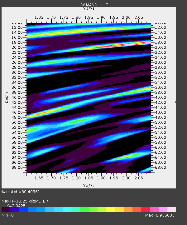
| Estimated Moho Depth: |
18.25 km |
| Estimated Crust Vp/Vs: |
2.04 |
| Assumed Crust Vp: |
6.597 km/s |
| Estimated Crust Vs: |
3.23 km/s |
| Estimated Crust Poisson's Ratio: |
0.34 |
|
| Radial Match: |
80.40961 % |
| Radial Bump: |
400 |
| Transverse Match: |
69.70355 % |
| Transverse Bump: |
400 |
| SOD ConfigId: |
28208852 |
| Insert Time: |
2022-07-23 00:08:22.439 +0000 |
| GWidth: |
2.5 |
| Max Bumps: |
400 |
| Tol: |
0.001 |
|

Signal To Noise
| Channel | StoN | STA | LTA |
| UW:MANO: :HHZ:20220708T23:47:37.030029Z | 12.632283 | 1.1938835E-6 | 9.4510504E-8 |
| UW:MANO: :HHN:20220708T23:47:37.030029Z | 2.065537 | 1.7383941E-7 | 8.416185E-8 |
| UW:MANO: :HHE:20220708T23:47:37.030029Z | 2.288607 | 2.4942977E-7 | 1.0898761E-7 |
| Arrivals |
| Ps | 3.0 SECOND |
| PpPs | 8.2 SECOND |
| PsPs/PpSs | 11 SECOND |


