You are here: Home > Network List > UW - Pacific Northwest Regional Seismic Network Stations List
> Station MOX Moxee City, WA, USA (was ISC code MXC) > Earthquake Result Viewer
MOX Moxee City, WA, USA (was ISC code MXC) - Earthquake Result Viewer
| Earthquake location: |
Mariana Islands |
| Earthquake latitude/longitude: |
18.8/146.8 |
| Earthquake time(UTC): |
2022/07/08 (189) 23:36:11 GMT |
| Earthquake Depth: |
23 km |
| Earthquake Magnitude: |
6.3 Mi |
| Earthquake Catalog/Contributor: |
NEIC PDE/pt |
|
| Network: |
UW Pacific Northwest Regional Seismic Network |
| Station: |
MOX Moxee City, WA, USA (was ISC code MXC) |
| Lat/Lon: |
46.58 N/120.30 W |
| Elevation: |
501 m |
|
| Distance: |
78.5 deg |
| Az: |
44.663 deg |
| Baz: |
285.152 deg |
| Ray Param: |
0.04955056 |
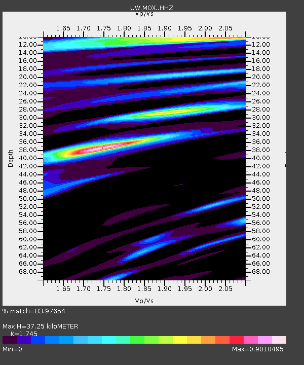
| Estimated Moho Depth: |
37.25 km |
| Estimated Crust Vp/Vs: |
1.75 |
| Assumed Crust Vp: |
6.597 km/s |
| Estimated Crust Vs: |
3.781 km/s |
| Estimated Crust Poisson's Ratio: |
0.26 |
|
| Radial Match: |
83.97654 % |
| Radial Bump: |
400 |
| Transverse Match: |
81.19741 % |
| Transverse Bump: |
400 |
| SOD ConfigId: |
28208852 |
| Insert Time: |
2022-07-23 00:08:25.267 +0000 |
| GWidth: |
2.5 |
| Max Bumps: |
400 |
| Tol: |
0.001 |
|

Signal To Noise
| Channel | StoN | STA | LTA |
| UW:MOX: :HHZ:20220708T23:47:39.119995Z | 13.507908 | 8.557473E-7 | 6.335158E-8 |
| UW:MOX: :HHN:20220708T23:47:39.119995Z | 2.0281796 | 1.09086244E-7 | 5.3785293E-8 |
| UW:MOX: :HHE:20220708T23:47:39.119995Z | 3.946608 | 2.3238616E-7 | 5.8882502E-8 |
| Arrivals |
| Ps | 4.3 SECOND |
| PpPs | 15 SECOND |
| PsPs/PpSs | 19 SECOND |


