You are here: Home > Network List > UW - Pacific Northwest Regional Seismic Network Stations List
> Station PAN4H Panhandle 4H Camp, Shelton, WA, USA > Earthquake Result Viewer
PAN4H Panhandle 4H Camp, Shelton, WA, USA - Earthquake Result Viewer
| Earthquake location: |
Mariana Islands |
| Earthquake latitude/longitude: |
18.8/146.8 |
| Earthquake time(UTC): |
2022/07/08 (189) 23:36:11 GMT |
| Earthquake Depth: |
23 km |
| Earthquake Magnitude: |
6.3 Mi |
| Earthquake Catalog/Contributor: |
NEIC PDE/pt |
|
| Network: |
UW Pacific Northwest Regional Seismic Network |
| Station: |
PAN4H Panhandle 4H Camp, Shelton, WA, USA |
| Lat/Lon: |
47.18 N/123.27 W |
| Elevation: |
132 m |
|
| Distance: |
76.4 deg |
| Az: |
44.575 deg |
| Baz: |
282.971 deg |
| Ray Param: |
0.0509933 |
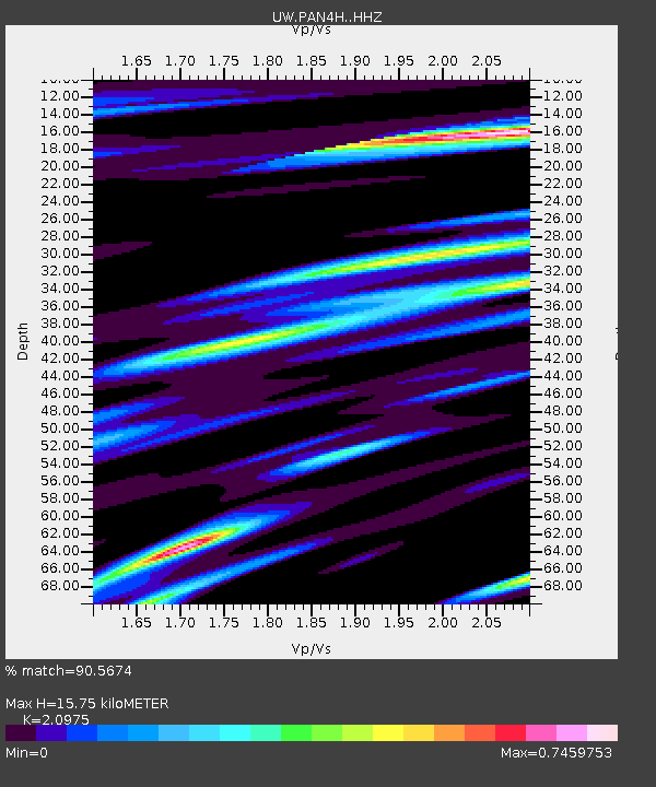
| Estimated Moho Depth: |
15.75 km |
| Estimated Crust Vp/Vs: |
2.10 |
| Assumed Crust Vp: |
6.566 km/s |
| Estimated Crust Vs: |
3.13 km/s |
| Estimated Crust Poisson's Ratio: |
0.35 |
|
| Radial Match: |
90.5674 % |
| Radial Bump: |
360 |
| Transverse Match: |
87.80751 % |
| Transverse Bump: |
400 |
| SOD ConfigId: |
28208852 |
| Insert Time: |
2022-07-23 00:08:37.223 +0000 |
| GWidth: |
2.5 |
| Max Bumps: |
400 |
| Tol: |
0.001 |
|

Signal To Noise
| Channel | StoN | STA | LTA |
| UW:PAN4H: :HHZ:20220708T23:47:27.289978Z | 13.508615 | 7.757222E-7 | 5.742426E-8 |
| UW:PAN4H: :HHN:20220708T23:47:27.289978Z | 0.83212787 | 4.3824016E-8 | 5.2665E-8 |
| UW:PAN4H: :HHE:20220708T23:47:27.289978Z | 4.150103 | 2.2209892E-7 | 5.3516484E-8 |
| Arrivals |
| Ps | 2.7 SECOND |
| PpPs | 7.2 SECOND |
| PsPs/PpSs | 9.9 SECOND |


