You are here: Home > Network List > UW - Pacific Northwest Regional Seismic Network Stations List
> Station CROWN Crown Point, Clallam County, WA, USA > Earthquake Result Viewer
CROWN Crown Point, Clallam County, WA, USA - Earthquake Result Viewer
| Earthquake location: |
Mariana Islands |
| Earthquake latitude/longitude: |
18.8/146.8 |
| Earthquake time(UTC): |
2022/07/08 (189) 23:36:11 GMT |
| Earthquake Depth: |
23 km |
| Earthquake Magnitude: |
6.3 Mi |
| Earthquake Catalog/Contributor: |
NEIC PDE/pt |
|
| Network: |
UW Pacific Northwest Regional Seismic Network |
| Station: |
CROWN Crown Point, Clallam County, WA, USA |
| Lat/Lon: |
48.30 N/124.48 W |
| Elevation: |
399 m |
|
| Distance: |
75.4 deg |
| Az: |
43.62 deg |
| Baz: |
281.846 deg |
| Ray Param: |
0.051692266 |
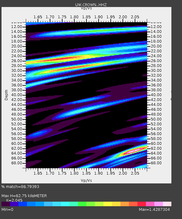
| Estimated Moho Depth: |
62.75 km |
| Estimated Crust Vp/Vs: |
2.05 |
| Assumed Crust Vp: |
6.391 km/s |
| Estimated Crust Vs: |
3.125 km/s |
| Estimated Crust Poisson's Ratio: |
0.34 |
|
| Radial Match: |
86.79393 % |
| Radial Bump: |
400 |
| Transverse Match: |
78.46462 % |
| Transverse Bump: |
400 |
| SOD ConfigId: |
28208852 |
| Insert Time: |
2022-07-23 00:10:31.470 +0000 |
| GWidth: |
2.5 |
| Max Bumps: |
400 |
| Tol: |
0.001 |
|

Signal To Noise
| Channel | StoN | STA | LTA |
| UW:CROWN: :HHZ:20220708T23:47:21.380005Z | 7.573309 | 7.2171514E-7 | 9.5297196E-8 |
| UW:CROWN: :HHN:20220708T23:47:21.380005Z | 1.072301 | 1.6208566E-7 | 1.5115685E-7 |
| UW:CROWN: :HHE:20220708T23:47:21.380005Z | 2.0978992 | 2.5993396E-7 | 1.2390201E-7 |
| Arrivals |
| Ps | 11 SECOND |
| PpPs | 29 SECOND |
| PsPs/PpSs | 40 SECOND |


