You are here: Home > Network List > TX - Texas Seismological Network Stations List
> Station PLPT Palo Pinto > Earthquake Result Viewer
PLPT Palo Pinto - Earthquake Result Viewer
| Earthquake location: |
Fiji Islands Region |
| Earthquake latitude/longitude: |
-18.2/-178.1 |
| Earthquake time(UTC): |
2018/08/19 (231) 00:19:37 GMT |
| Earthquake Depth: |
563 km |
| Earthquake Magnitude: |
8.2 mww |
| Earthquake Catalog/Contributor: |
NEIC PDE/us |
|
| Network: |
TX Texas Seismological Network |
| Station: |
PLPT Palo Pinto |
| Lat/Lon: |
32.81 N/98.32 W |
| Elevation: |
336 m |
|
| Distance: |
91.5 deg |
| Az: |
56.001 deg |
| Baz: |
249.386 deg |
| Ray Param: |
0.041233562 |
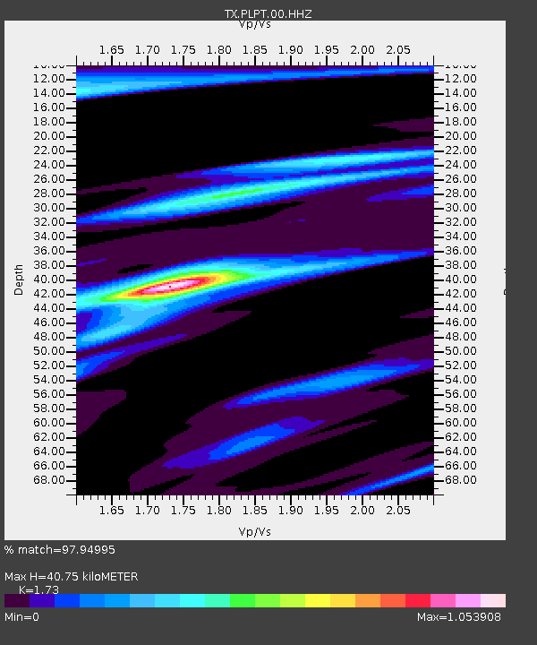
| Estimated Moho Depth: |
40.75 km |
| Estimated Crust Vp/Vs: |
1.73 |
| Assumed Crust Vp: |
6.426 km/s |
| Estimated Crust Vs: |
3.715 km/s |
| Estimated Crust Poisson's Ratio: |
0.25 |
|
| Radial Match: |
97.94995 % |
| Radial Bump: |
310 |
| Transverse Match: |
88.942635 % |
| Transverse Bump: |
400 |
| SOD ConfigId: |
2825771 |
| Insert Time: |
2018-09-02 01:43:18.766 +0000 |
| GWidth: |
2.5 |
| Max Bumps: |
400 |
| Tol: |
0.001 |
|

Signal To Noise
| Channel | StoN | STA | LTA |
| TX:PLPT:00:HHZ:20180819T00:31:13.139983Z | 15.576696 | 1.3419622E-6 | 8.615191E-8 |
| TX:PLPT:00:HH1:20180819T00:31:13.139983Z | 7.161308 | 4.4161925E-7 | 6.16674E-8 |
| TX:PLPT:00:HH2:20180819T00:31:13.139983Z | 3.3605866 | 2.0539152E-7 | 6.111775E-8 |
| Arrivals |
| Ps | 4.7 SECOND |
| PpPs | 17 SECOND |
| PsPs/PpSs | 22 SECOND |


