You are here: Home > Network List > TX - Texas Seismological Network Stations List
> Station SMWD Samnorwood > Earthquake Result Viewer
SMWD Samnorwood - Earthquake Result Viewer
| Earthquake location: |
Fiji Islands Region |
| Earthquake latitude/longitude: |
-18.2/-178.1 |
| Earthquake time(UTC): |
2018/08/19 (231) 00:19:37 GMT |
| Earthquake Depth: |
563 km |
| Earthquake Magnitude: |
8.2 mww |
| Earthquake Catalog/Contributor: |
NEIC PDE/us |
|
| Network: |
TX Texas Seismological Network |
| Station: |
SMWD Samnorwood |
| Lat/Lon: |
35.10 N/100.24 W |
| Elevation: |
704 m |
|
| Distance: |
90.8 deg |
| Az: |
53.291 deg |
| Baz: |
248.367 deg |
| Ray Param: |
0.04136455 |
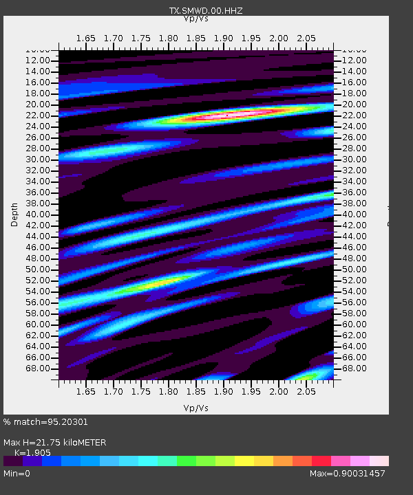
| Estimated Moho Depth: |
21.75 km |
| Estimated Crust Vp/Vs: |
1.90 |
| Assumed Crust Vp: |
6.426 km/s |
| Estimated Crust Vs: |
3.373 km/s |
| Estimated Crust Poisson's Ratio: |
0.31 |
|
| Radial Match: |
95.20301 % |
| Radial Bump: |
400 |
| Transverse Match: |
88.2317 % |
| Transverse Bump: |
400 |
| SOD ConfigId: |
2825771 |
| Insert Time: |
2018-09-02 01:43:22.499 +0000 |
| GWidth: |
2.5 |
| Max Bumps: |
400 |
| Tol: |
0.001 |
|

Signal To Noise
| Channel | StoN | STA | LTA |
| TX:SMWD:00:HHZ:20180819T00:31:10.079985Z | 8.266796 | 9.604304E-7 | 1.1617929E-7 |
| TX:SMWD:00:HH1:20180819T00:31:10.079985Z | 2.5630224 | 1.1776065E-7 | 4.5946006E-8 |
| TX:SMWD:00:HH2:20180819T00:31:10.079985Z | 8.324151 | 3.3941285E-7 | 4.077447E-8 |
| Arrivals |
| Ps | 3.1 SECOND |
| PpPs | 9.6 SECOND |
| PsPs/PpSs | 13 SECOND |


