You are here: Home > Network List > 1E - GSC-BCOGC Induced Seismicity Study Stations List
> Station BCH2A Z > Earthquake Result Viewer
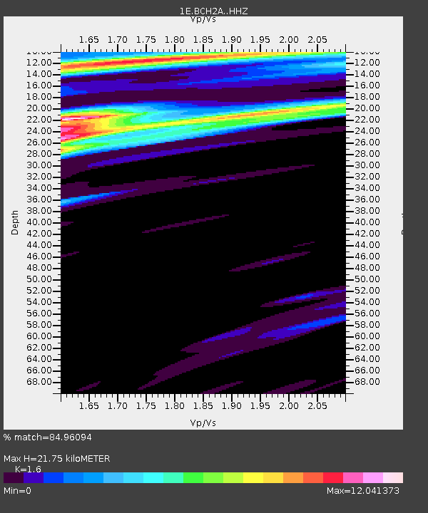
BCH2A Z - Earthquake Result Viewer
| Earthquake location: |
Kermadec Islands Region |
| Earthquake latitude/longitude: |
-28.0/-176.5 |
| Earthquake time(UTC): |
2022/07/09 (190) 07:39:54 GMT |
| Earthquake Depth: |
10 km |
| Earthquake Magnitude: |
5.4 Mww |
| Earthquake Catalog/Contributor: |
NEIC PDE/us |
|
| Network: |
1E GSC-BCOGC Induced Seismicity Study |
| Station: |
BCH2A Z |
| Lat/Lon: |
55.95 N/120.36 W |
| Elevation: |
761 m |
|
| Distance: |
96.2 deg |
| Az: |
28.047 deg |
| Baz: |
227.674 deg |
| Ray Param: |
0.040571626 |
| Estimated Moho Depth: |
21.75 km |
| Estimated Crust Vp/Vs: |
1.60 |
| Assumed Crust Vp: |
6.303 km/s |
| Estimated Crust Vs: |
3.939 km/s |
| Estimated Crust Poisson's Ratio: |
0.18 |
|
| Radial Match: |
84.96094 % |
| Radial Bump: |
400 |
| Transverse Match: |
87.419334 % |
| Transverse Bump: |
400 |
| SOD ConfigId: |
28208852 |
| Insert Time: |
2022-07-23 07:41:23.302 +0000 |
| GWidth: |
2.5 |
| Max Bumps: |
400 |
| Tol: |
0.001 |
|

Signal To Noise
| Channel | StoN | STA | LTA |
| 1E:BCH2A: :HHZ:20220709T07:52:51.579972Z | 2.1015732 | 1.7074473E-7 | 8.124616E-8 |
| 1E:BCH2A: :HHN:20220709T07:52:51.579972Z | 3.38123 | 2.3573618E-6 | 6.971906E-7 |
| 1E:BCH2A: :HHE:20220709T07:52:51.579972Z | 3.4494169 | 1.3618431E-6 | 3.9480386E-7 |
| Arrivals |
| Ps | 2.1 SECOND |
| PpPs | 8.8 SECOND |
| PsPs/PpSs | 11 SECOND |


