You are here: Home > Network List > TX - Texas Seismological Network Stations List
> Station PB06 Permian Basin 6 > Earthquake Result Viewer
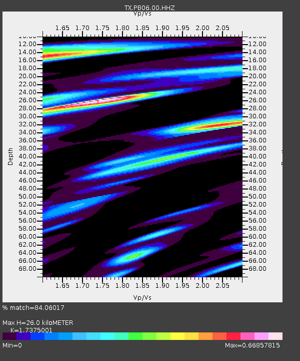
PB06 Permian Basin 6 - Earthquake Result Viewer
| Earthquake location: |
Fiji Islands Region |
| Earthquake latitude/longitude: |
-18.2/-178.1 |
| Earthquake time(UTC): |
2018/08/19 (231) 00:19:37 GMT |
| Earthquake Depth: |
563 km |
| Earthquake Magnitude: |
8.2 mww |
| Earthquake Catalog/Contributor: |
NEIC PDE/us |
|
| Network: |
TX Texas Seismological Network |
| Station: |
PB06 Permian Basin 6 |
| Lat/Lon: |
31.65 N/103.22 W |
| Elevation: |
831 m |
|
| Distance: |
87.2 deg |
| Az: |
55.527 deg |
| Baz: |
246.777 deg |
| Ray Param: |
0.04192907 |
| Estimated Moho Depth: |
26.0 km |
| Estimated Crust Vp/Vs: |
1.74 |
| Assumed Crust Vp: |
6.121 km/s |
| Estimated Crust Vs: |
3.523 km/s |
| Estimated Crust Poisson's Ratio: |
0.25 |
|
| Radial Match: |
84.06017 % |
| Radial Bump: |
400 |
| Transverse Match: |
73.1115 % |
| Transverse Bump: |
400 |
| SOD ConfigId: |
2825771 |
| Insert Time: |
2018-09-02 01:43:31.380 +0000 |
| GWidth: |
2.5 |
| Max Bumps: |
400 |
| Tol: |
0.001 |
|

Signal To Noise
| Channel | StoN | STA | LTA |
| TX:PB06:00:HHZ:20180819T00:30:53.370024Z | 5.373414 | 6.0622E-7 | 1.12818405E-7 |
| TX:PB06:00:HH1:20180819T00:30:53.370024Z | 1.2178748 | 7.171602E-8 | 5.8886204E-8 |
| TX:PB06:00:HH2:20180819T00:30:53.370024Z | 2.0221817 | 1.5791579E-7 | 7.809179E-8 |
| Arrivals |
| Ps | 3.2 SECOND |
| PpPs | 11 SECOND |
| PsPs/PpSs | 15 SECOND |


