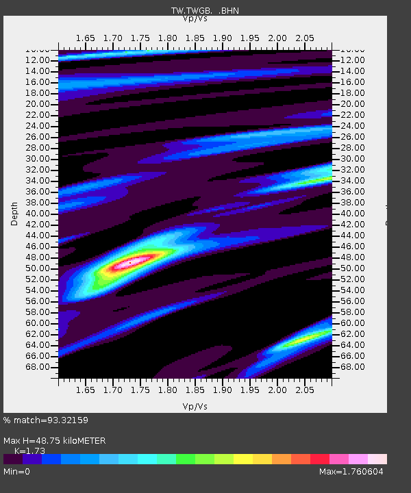
TWGB TAI-TUNG - Earthquake Result Viewer

Earthquake location: Northern Sumatra, Indonesia
Earthquake latitude/longitude: 2.1/97.1
Earthquake time(UTC): 2005/03/28 (087) 16:09:36 GMT
Earthquake Depth: 30 km
Earthquake Magnitude: 7.2 MB, 8.4 MS, 8.7 MW, 8.1 MW
Earthquake Catalog/Contributor: WHDF/NEIC
Network: TW Broadband Array in Taiwan for Seismology
Station: TWGB TAI-TUNG
Lat/Lon: 22.82 N/121.08 E
Elevation: 195 m
Distance: 31.1 deg
Az: 46.57 deg
Baz: 231.866 deg
Ray Param: 0.07913747
Estimated Moho Depth: 48.75 km
Estimated Crust Vp/Vs: 1.73
Assumed Crust Vp: 6.461 km/s
Estimated Crust Vs: 3.735 km/s
Estimated Crust Poisson's Ratio: 0.25
Radial Match: 93.32159 %
Radial Bump: 293
Transverse Match: 85.02045 %
Transverse Bump: 400
SOD ConfigId: 2459
Insert Time: 2010-03-09 22:06:29.457 +0000
GWidth: 2.5
Max Bumps: 400
Tol: 0.001

Signal To Noise

ChannelStoNSTALTA
TW:TWGB: :BHN:20050328T16:15:21.648988Z5.22336772.9907796E-65.725769E-7
TW:TWGB: :BHE:20050328T16:15:21.648988Z6.11385353.47678E-65.686725E-7
TW:TWGB: :BHZ:20050328T16:15:21.648988Z5.3453755.0078183E-69.368507E-7
Arrivals
Ps6.0 SECOND
PpPs19 SECOND
PsPs/PpSs25 SECOND