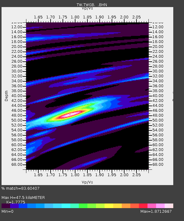
TWGB TAI-TUNG - Earthquake Result Viewer

Earthquake location: Northern Sumatra, Indonesia
Earthquake latitude/longitude: 0.6/98.5
Earthquake time(UTC): 2005/05/14 (134) 05:05:18 GMT
Earthquake Depth: 34 km
Earthquake Magnitude: 6.4 MB, 6.8 MS, 6.8 MW, 6.8 MW
Earthquake Catalog/Contributor: WHDF/NEIC
Network: TW Broadband Array in Taiwan for Seismology
Station: TWGB TAI-TUNG
Lat/Lon: 22.82 N/121.08 E
Elevation: 195 m
Distance: 31.2 deg
Az: 43.277 deg
Baz: 227.983 deg
Ray Param: 0.07910553
Estimated Moho Depth: 47.5 km
Estimated Crust Vp/Vs: 1.78
Assumed Crust Vp: 6.461 km/s
Estimated Crust Vs: 3.635 km/s
Estimated Crust Poisson's Ratio: 0.27
Radial Match: 83.60407 %
Radial Bump: 391
Transverse Match: 70.86318 %
Transverse Bump: 400
SOD ConfigId: 2455
Insert Time: 2010-03-09 22:06:41.944 +0000
GWidth: 2.5
Max Bumps: 400
Tol: 0.001

Signal To Noise

ChannelStoNSTALTA
TW:TWGB: :BHN:20050514T05:11:04.098988Z10.063172.3944854E-62.3794541E-7
TW:TWGB: :BHE:20050514T05:11:04.098988Z7.44412571.6150603E-62.1695769E-7
TW:TWGB: :BHZ:20050514T05:11:04.098988Z24.1843625.9083104E-62.4430292E-7
Arrivals
Ps6.2 SECOND
PpPs19 SECOND
PsPs/PpSs25 SECOND