You are here: Home > Network List > US - United States National Seismic Network Stations List
> Station DGMT Dagmar, Montana, USA > Earthquake Result Viewer
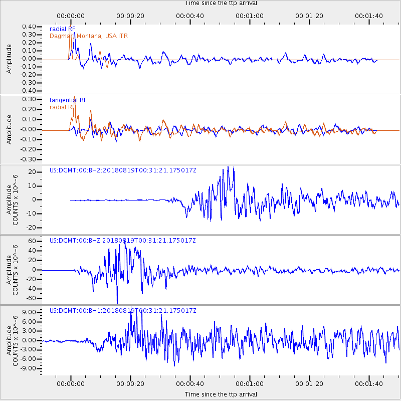
DGMT Dagmar, Montana, USA - Earthquake Result Viewer
*The percent match for this event was below the threshold and hence no stack was calculated.
| Earthquake location: |
Fiji Islands Region |
| Earthquake latitude/longitude: |
-18.2/-178.1 |
| Earthquake time(UTC): |
2018/08/19 (231) 00:19:37 GMT |
| Earthquake Depth: |
563 km |
| Earthquake Magnitude: |
8.2 mww |
| Earthquake Catalog/Contributor: |
NEIC PDE/us |
|
| Network: |
US United States National Seismic Network |
| Station: |
DGMT Dagmar, Montana, USA |
| Lat/Lon: |
48.47 N/104.20 W |
| Elevation: |
0.0 m |
|
| Distance: |
93.2 deg |
| Az: |
39.826 deg |
| Baz: |
246.197 deg |
| Ray Param: |
$rayparam |
*The percent match for this event was below the threshold and hence was not used in the summary stack. |
|
| Radial Match: |
97.87994 % |
| Radial Bump: |
400 |
| Transverse Match: |
92.16926 % |
| Transverse Bump: |
400 |
| SOD ConfigId: |
2825771 |
| Insert Time: |
2018-09-02 01:43:46.871 +0000 |
| GWidth: |
2.5 |
| Max Bumps: |
400 |
| Tol: |
0.001 |
|
Signal To Noise
| Channel | StoN | STA | LTA |
| US:DGMT:00:BHZ:20180819T00:31:21.175017Z | 12.158301 | 2.6239354E-6 | 2.1581431E-7 |
| US:DGMT:00:BH1:20180819T00:31:21.175017Z | 1.2163634 | 1.8764578E-7 | 1.5426787E-7 |
| US:DGMT:00:BH2:20180819T00:31:21.175017Z | 2.9468591 | 6.08542E-7 | 2.065053E-7 |
| Arrivals |
| Ps | |
| PpPs | |
| PsPs/PpSs | |


