You are here: Home > Network List > TW - Broadband Array in Taiwan for Seismology Stations List
> Station TWGB TAI-TUNG > Earthquake Result Viewer
TWGB TAI-TUNG - Earthquake Result Viewer
| Earthquake location: |
Southern Sumatra, Indonesia |
| Earthquake latitude/longitude: |
-0.7/99.9 |
| Earthquake time(UTC): |
2009/09/30 (273) 10:16:09 GMT |
| Earthquake Depth: |
81 km |
| Earthquake Magnitude: |
7.1 MB, 7.5 MW, 7.5 MW |
| Earthquake Catalog/Contributor: |
WHDF/NEIC |
|
| Network: |
TW Broadband Array in Taiwan for Seismology |
| Station: |
TWGB TAI-TUNG |
| Lat/Lon: |
22.82 N/121.08 E |
| Elevation: |
195 m |
|
| Distance: |
31.2 deg |
| Az: |
40.112 deg |
| Baz: |
224.285 deg |
| Ray Param: |
0.07897114 |
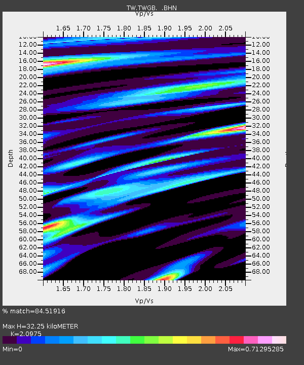
| Estimated Moho Depth: |
32.25 km |
| Estimated Crust Vp/Vs: |
2.10 |
| Assumed Crust Vp: |
6.461 km/s |
| Estimated Crust Vs: |
3.081 km/s |
| Estimated Crust Poisson's Ratio: |
0.35 |
|
| Radial Match: |
84.51916 % |
| Radial Bump: |
400 |
| Transverse Match: |
72.23266 % |
| Transverse Bump: |
400 |
| SOD ConfigId: |
2622 |
| Insert Time: |
2010-03-09 22:06:54.349 +0000 |
| GWidth: |
2.5 |
| Max Bumps: |
400 |
| Tol: |
0.001 |
|

Signal To Noise
| Channel | StoN | STA | LTA |
| TW:TWGB: :BHN:20090930T10:21:50.720001Z | 43.70673 | 2.161458E-4 | 4.9453665E-6 |
| TW:TWGB: :BHE:20090930T10:21:50.720001Z | 24.297207 | 5.662296E-5 | 2.330431E-6 |
| TW:TWGB: :BHZ:20090930T10:21:50.720001Z | 20.601921 | 8.024979E-5 | 3.8952576E-6 |
| Arrivals |
| Ps | 5.9 SECOND |
| PpPs | 14 SECOND |
| PsPs/PpSs | 20 SECOND |


