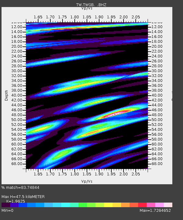
TWGB TAI-TUNG - Earthquake Result Viewer

Earthquake location: Southeast Of Loyalty Islands
Earthquake latitude/longitude: -21.6/169.8
Earthquake time(UTC): 1998/07/31 (212) 12:40:59 GMT
Earthquake Depth: 33 km
Earthquake Magnitude: 5.9 MS, 5.4 MB, 6.1 UNKNOWN, 6.0 MW
Earthquake Catalog/Contributor: WHDF/NEIC
Network: TW Broadband Array in Taiwan for Seismology
Station: TWGB TAI-TUNG
Lat/Lon: 22.82 N/121.08 E
Elevation: 195 m
Distance: 64.8 deg
Az: 309.983 deg
Baz: 129.397 deg
Ray Param: 0.058605004
Estimated Moho Depth: 47.5 km
Estimated Crust Vp/Vs: 1.96
Assumed Crust Vp: 6.461 km/s
Estimated Crust Vs: 3.292 km/s
Estimated Crust Poisson's Ratio: 0.32
Radial Match: 83.74844 %
Radial Bump: 400
Transverse Match: 83.6506 %
Transverse Bump: 400
SOD ConfigId: 4480
Insert Time: 2010-03-09 22:07:00.032 +0000
GWidth: 2.5
Max Bumps: 400
Tol: 0.001

Signal To Noise

ChannelStoNSTALTA
TW:TWGB: :BHZ:19980731T12:51:04.421021Z3.49244242.8974836E-78.296439E-8
TW:TWGB: :BHN:19980731T12:51:04.421021Z1.24400091.2200103E-79.807149E-8
TW:TWGB: :BHE:19980731T12:51:04.421021Z1.8769282.3446381E-71.2491891E-7
Arrivals
Ps7.4 SECOND
PpPs21 SECOND
PsPs/PpSs28 SECOND