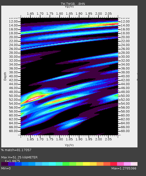
TWGB TAI-TUNG - Earthquake Result Viewer

Earthquake location: New Britain Region, P.N.G.
Earthquake latitude/longitude: -5.2/151.8
Earthquake time(UTC): 2000/11/18 (323) 06:54:58 GMT
Earthquake Depth: 33 km
Earthquake Magnitude: 6.2 MB, 6.6 MS, 6.8 MW, 6.8 MW
Earthquake Catalog/Contributor: WHDF/NEIC
Network: TW Broadband Array in Taiwan for Seismology
Station: TWGB TAI-TUNG
Lat/Lon: 22.82 N/121.08 E
Elevation: 195 m
Distance: 41.0 deg
Az: 314.066 deg
Baz: 129.143 deg
Ray Param: 0.0740293
Estimated Moho Depth: 51.25 km
Estimated Crust Vp/Vs: 1.67
Assumed Crust Vp: 6.461 km/s
Estimated Crust Vs: 3.875 km/s
Estimated Crust Poisson's Ratio: 0.22
Radial Match: 81.17057 %
Radial Bump: 400
Transverse Match: 60.720146 %
Transverse Bump: 400
SOD ConfigId: 3744
Insert Time: 2010-03-09 22:07:22.389 +0000
GWidth: 2.5
Max Bumps: 400
Tol: 0.001

Signal To Noise

ChannelStoNSTALTA
TW:TWGB: :BHN:20001118T07:02:07.382013Z2.11382461.1535186E-65.457021E-7
TW:TWGB: :BHE:20001118T07:02:07.382013Z1.12676799.720276E-78.626689E-7
TW:TWGB: :BHZ:20001118T07:02:07.382013Z3.2630282.476225E-67.588734E-7
Arrivals
Ps5.7 SECOND
PpPs20 SECOND
PsPs/PpSs25 SECOND